Exploring Unknown Environments with Mobile Robots using Coverage Maps
Proceedings of the Eighteenth International Joint Conference on Artificial Intelligence. Pages 1127-1133.
© 2003 International Joint Conferences on Artificial Intelligence
Abstract
In this paper we introduce coverage maps as a new way of representing the environment of a mobile robot. Coverage maps store for each cell of a given grid a posterior about the amount the corresponding cell is covered by an obstacle. Using this representation a mobile robot can more accurately reason about its uncertainty in the map of the environment than with standard occupancy grids. We present a model for proximity sensors designed to update coverage maps upon sensory input. We also describe how coverage maps can be used to formulate a decision-theoretic approach for mobile robot exploration. We present experiments carried out with real robots in which accurate maps are build from noisy ultrasound data. Finally, we present a comparison of different view-point selection strategies for mobile robot exploration.
- F. Bourgault, A. A. Makarenko, S. B. Williams, B. Grocholsky, and F. Durrant- Whyte. Information based adaptive robotic exploration. In Proc. of the IEEEIRSJ Int. Conf on Intelligent Robots and Systems (IROS), 2002.
- W. Burgard, M. Moors, and F. Schneider. Collaborative exploration of unknown environments with teams of mobile robots. In dagstuhl. Springer Verlag, 2002.
- H. Choset. Coverage for robitics -a survey of recent results. Annals of Mathe- matics and Artifica/ lntelligence, 31, 2001.
- H. Choset. Topological simultaneous localization and mapping (slam): Toward exact localization without explicit localization. IEEE Transactions 011 Robotics and Automation, 17(2), April 2001.
- G. Dissanayake, H. Durrant-Whyte, and T. Bailey. A computationally efficient solution to the simultaneous localisation and map building (SLAM) problem. Working notes of ICRA'2000 Workshop W4: Mobile Robot Navigation and Mapping, April 2000.
- G. Dudek, M. Jenkin, E. Milios, and D. Wilkes. Robotic exploration as graph construction. IEEE Transactions on Robotics and Automation, 7(6):859-865, 1991.
- T. Edlinger and E. von Puttkamer. Exploration of an indoor-environment by an autonomous mobile robot. In Proc. of the IEEEIRSJ Int. Conf on llllelligent Robots and Systems (IROS), 1994.
- H.H. Gonzalez-Banos and J.C. Latombe. Navigation strategies for exploring indoor environments. International Journal of Robotics Research, 200 I.
- J.-S. Gutmann and K. Konolige. Incremental mapping of large cyclic environ- ments. In Proc. of the International Symposium on Computational Intelligence in Robotics and Automation (C/RA), 2000.
- D. Hahne!, D. Schulz, and W. Burgard. Map building with mobile robots in pop- ulated environments. In Proc. of the IEEEIRSJ Int. Co11j on Intelligent Robots and Systems (IROS), 2002.
- S. Koenig, C. Tovey, and W. Halliburton. Greedy mapping of terrain. In Proc. of the IEEE Int. Conf on Robotics & Automation (ICRA ), 2001.
- N. Massios, L. Dorst, and F. Voorbraak. A strategy for robot surveillancs usi ng the geometrical structure of the environment,. In /JCAI Workshop "Reasoning with Uncertainty in Robotics", 2001.
- S.J. Moorehead, R. Simmons, and W.L. Whittaker. Autonomous exploration us- ing multiple sources of information. In Proc. of the IEEE Int. Conf on Robotics & Automation (ICRA), 2001.
- Hans P. Moravec and A.E. Elfes. High resolution maps from wide angle sonar. In Proc. IEEE Int. Conf Robotics and Automation, pages 116-121 , 1985.
- R. Simmons, D. Apfelbaum, W. Burgard, D. Fox, M. Moors, S. Thrun, and H. Younes. Coordination for multi-robot exploration and mapping. In Proc. of the National Conference on Artificial Intelligence (AAAI), 2000.
- C.J. Tailor and D.J. Kriegman. Exloration strategies for mobile robots. In Proc. of the IEEE Int. Conf on Robotics & Automation (ICRA), pages 248-253, 1993.
- S. Thrun. An online mapping algorithm for teams of mobile robots. lnterna• tiona/ Journal of Robotics Research, 200 I.
- S. Thrun . Learning occupancy grids with forward sensor models. Autonomous Robots, 2002. To appear.
- P. Whaite and F. P. Ferrie. Autonomous exploration: Driven by uncertainty. IEEE Transactions on Pattern Analysis and Machine Intelligence, 19(3): 193- 205, 1997.
- B. Yamauchi, A. Schultz, and W. Adams. Integrating exploration and localiza- tion for mobile robots. Adaptive Systems, 7(2), 1999.
References were extracted automatically from the PDF and may contain errors.
Full text extracted automatically from the PDF; figures, tables and equations may differ. The PDF is the version of record.
1 Introduction
Generating maps is one of the fundamental tasks of mobile robots and many researchers have focused on the problem of how to represent the environment as well as how to acquire models using this representation [5, 9, 10, 14, 17]. The map ping problem itself has several aspects that have been studied intensively in the past. Some of the most important aspects are the localization of the vehicle during mapping, appropri ate models of the environment and the sensors, as well as strategies for guiding the vehicle. In literature, the localiza tion problem plays an important role, since the quality of the resulting map depends strongly on the accuracy of the pose estimates during the mapping process. However, the accu racy of the map also depends on the choice of view-points during exploration. Especially if noisy sensors are used, the map will be quite inaccurate in areas which have been sensed a few times only or maybe even from disadvantageous view points.
Exploration is the task of guiding a vehicle in such a way that it covers the environment with its sensors. Efficient ex ploration strategies are also relevant for surface inspection, mine sweeping, or surveillance [3, 12]. In the past, several strategies for exploration have been developed. One group of approaches deals with the problem of simultaneous local ization and mapping [I, 4], an aspect that we do not address in this paper. A common technique for exploration strategies is to extract frontiers between known and unknown areas [2, 7, 20] and to visit the nearest unexplored place. These ap proaches only distinguish between scanned and un-scanned areas and do not take into account the actual information gath ered at each view-point. To overcome this limitation, Gonza les et a!. [8] determine the amount of unseen area that might be visible to the robot from possible view-points. To incorpo rate the uncertainty of the robot about the state of the environ ment Moorehead et a!. [ 13] as well as Bourgault et a!. [ 1] use occupancy grids [14] and compute the entropy of each cell in the grid to determine the utility of scanning from a certain lo cation. Whaite and Ferrie [19] present an approach that also uses the entropy to measure the uncertainty in the geometric structure of objects that are scanned with a laser range sensor. In contrast to the work described here they use a paramet ric representation of the objects to be scanned. Edlinger and Puttkamer [7] developed a hierarchical exploration strategy for office environments. Their approach first explores rooms and then traverses through doorways to explore other parts of the environment. Tailor and Krieg man [ 16] describe a sys tem for visiting all landmarks in the environment of the robot. Their robot maintains a list of unvisited landmarks that are ap proached and mapped by the robot. Dudek et a!. [6] propose a strategy for exploring an unknown graph-like environment. Their algorithm does not consider distance metrics and is de signed for robots with very limited perceptual capabilities. Recently Koenig has shown, that a strategy, which guides the vehicle to the closest point that has not been covered yet, keeps the traveled distance reasonably small [II] . However, as experiments reported in this paper illustrate, such tech niques can lead to a serious increase of measurements nec essary to build an accurate map if the robot is not able to incorporate measurements on-the-fly while it is moving. This might be the case, for example, for robots extracting distance information from camera images.
*This work has partly been supported by the German Science Foundation (DFG) under contract number SFBffR8-03.
In this paper we introduce coverage maps as a new proba bilistic way to represent the belief of the robot about the state of the environment. In contrast to occupancy grids [14], in which each cell is considered as either occupied or free, coverage maps represent in each cell of a given discretization a posterior about the amount this cell is covered by an object. As an example consider the situation depicted in Figure I in which a cell is partly covered by an obstacle. With the stan dard occupancy algorithm the probability that this cell is oc cupied will converge to 1 if the sensors of the robot repeatedly detect the obstacle. The left picture of this figure shows the resulting occupancy probabilities (black represents high like lihood). Since the object does only cover 20% of this cell, a coverage value of .2 (as shown in the right image of Figure I) would be a better approximation of the true situation. In ad dition to the representation aspect, we also present a sensor model that allows the robot to appropriately update a cover age map upon sensory input and describe how coverage maps can be used to realize a decision-theoretic approach to explo ration of unknown environments.
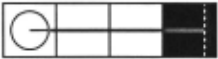
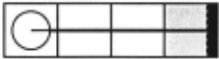
This paper is organized as follows. In the next section we introduce coverage maps. In Section 3 we present a proba bilistic technique to update a given coverage map upon sen sory input. In Section 4 we describe a decision-theoretic ap proach to exploration based on coverage maps. In Section 5 we present experiments illustrating that our approach allows a mobile robot can learn accurate maps from noisy range sen sors. Additionally, we present experiments comparing differ ent view-point selection strategies for exploration.
2 Coverage Maps
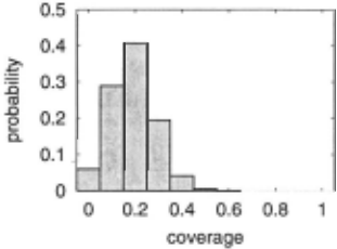
As already mentioned above, occupancy grids rest on the as sumption that the environment has binary structure, i.e. that each grid cell is either occupied or free. This assumption, however, is not always justified. For example, if the envi ronment contains a wall that is not parallel to the x- or y axis of the grid there must be grid cells which are only partly covered. In occupancy grids the probability that such cells are occupied will inevitably converge to one (see Figure I). Coverage maps overcome this limitation by storing a poste rior about its coverage for each cell. Coverage values range from 0 to 1. Whereas a coverage of 1 means that the cell is fully occupied, an empty cell has a coverage of 0. Since the robot usually does not know the true coverage of a grid cell, it maintains a probabilistic belief p(cL) about the coverage of the cell c1· In principle, there are different ways of represent ing p(cL) . They range from parametric distributions such as (mixtures of) Gaussians or non-parametric variants such as histograms. Throughout this paper we assume that each p( C!) is given by a histogram over possible coverage values. More precisely, we store a histogram for each grid cell, in which each bin contains the probability that the corresponding grid cell has the particular coverage. A typical example is depicted in Figure 2. It shows the posterior for the cell containing the obstacle in the situation illustrated in Figure I obtained after 30 measurements.
3 Updating Coverage Maps
To update a coverage map based on sensory input, we ap ply a Bayesian update scheme similar to that of occupancy grids. Throughout this paper we assume that our sensor pro vides distance information. Accordingly, we have to convert the distance information to coverage values. What we need to know is the coverage map c that has the highest likelihood under all distance measurements do , .. . , dr. If we use Bayes rule and assume that consecutive measurements are indepen dent given that we know the map c, we obtain:
Next we need to know how to determine the likelihood p( dt I c) of measuring dt given the map c. Again we apply Bayes rule and obtain: T
Equation (5) is obtained from Equation (4) by assuming that p(c) is constant and that~ = p(dt) is constant for every t. The variables f3 and (3' represent normalization constants ensuring that the left-hand side sums up to one over all c. Under the strong assumption that the individual cells of a coverage map are independent' we finally obtain:
1 This independence is frequently assumed in the context of occu pancy maps. We would like to refer to a recent work by Thrun [ 18] on how to better deal with the dependency between cells.
Thus, to update a map given a measurement dt we simply have to multiply the current belief about the coverage of each cell ct by the belief about the coverage of this cell resulting from dt. Additionally the maximum likelihood coverage map is obtained by choosing the mode of the coverage histogram for each cell Ct.
It remains to describe how we actually compute p(ct I dt), i.e. how we determine the distribution about the potential cov erage values of a cell c1 with distance d 1 to the sensor given a measurement dt. In our current system, we use a mixture of a Gaussian N(J.L, a) and a uniform distribution 'Y to compute the probability p(ct = x I dt) that the coverage of Ct is x:
The value of the uniform distribution is computed using the function 'Y(d 1 , dt) which increases monotonously in d 1 and d. It reflects a typical behavior of proximity sensors like sonars, because the accuracy of a measurement decreases with the distance to the obstacle.
The mean J.L( d 1 - d) of the Gaussian is computed in the following way:
where r is the grid resolution of the map. Note that we dis tinguish three situations, depending on whether the measure ment ends in c1 or not. Suppose that the measurement does not end in c1 and the distance d 1 is shorter than d. In this case we have d 1 - d < - ~. In such a situation, the mean of the Gaussian is zero, since it is more likely that a cell covered by a range measurement that does not end in it is completely empty. The second line of Equation (1 0) represents the situa tion in which d ends within c1· In this case the mean is inverse proportional to the amount the cell is covered by d. Finally, cells lying up to 20cm behind a cell, in which the measure ment ends, are most likely completely occupied so that the mean is 1.
The value of the standard deviation a(d 1 , d) of the Gaus sian also is a function that is monotonously increasing in d 1 and d except when ld 1 - dl < ~· In this range a(d 1 , d) has a constant value that exceeds all values outside of this interval.
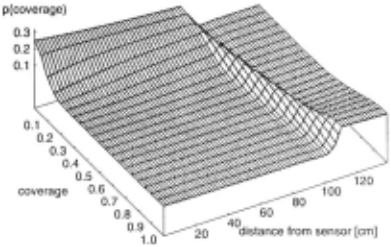
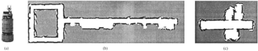
To obtain the optimal parameters for the functions in our sensor model we apply the maximum likelihood princi ple. We first apply a highly accurate scan-alignment proce dure [10] on laser range information. Next we manually ex tract geometric objects from the corresponding range data. Given these geometric primitives we use straightforward ge ometric projections to compute the ground truth information, i.e., the exact coverage of each cell of a given discretiza tion. We evaluate a particular setting for the parameters of our model by determining the likelihood of the ground truth given a coverage map obtained using this setting. To maximize the likelihood we apply local search techniques in the parameter space. Figure 3 plots p( c1 = x I d) for a measured distance of d = 1m obtained for ultrasound data recorded with our B21r robot Albert, which is depicted in picture (a) of Figure 4. As the plot illustrates, for a measured distance of 1m, cells close to the robot are unoccupied with high likelihood. However, cells close to the measured distance are covered with high probability. Figure 4 shows two coverage maps build from real sonar data obtained by a real robot. Image (b) depicts a map of the Sieg Hall at the University of Washington and (c) a map of the office environment of our laboratory.
4 Strategies for Choosing the Next View-Point
One of the key problems during exploration is to choose ap propriate vantage points. At the selected location the robot will perform the next measurement to retrieve new informa tion about its environment. In this section we will present four methods to choose an appropriate position. In general there are two different aspects that are relevant for the view point selection. On the one hand, the uncertainty of the robot in the map should be as small as possible, and on the other hand, the number of measurements to be incorporated as well as the distance traveled should be minimized.
To determine the uncertainty in the state of a particular cell we consider the entropy of the posterior for that cell. Entropy is a general measure for the uncertainty of a be lief. The entropy H of a histogram h consisting of n bins hi (i = 1, .. . , n) is defined as:
H is maximal in case of a uniform distribution. The mini mal value zero is obtained if the system is absolutely certain about the state of the corresponding cell. Thus, if we want to minimize the uncertainty in the current map, all we need to do is to reduce the entropy of the histograms in the coverage map. Furthermore, we can specify, at which moment the ex ploration task has been completed. Suppose the size of the environment is limited. Then the goal of the exploration pro cess for a coverage map c has been achieved if H(h(c1)) < <:: for all cells Ct E c that can be reached by the robot. Here h( Ct) corresponds to the histogram representing the coverage of Ct. Additionally, the system has to detect a situation in which the robot is unable to reduce the entropy of a cell below <:: to en sure the termination of the exploration task. In our system this is achieved by monitoring the change of entropy. If this change is below .001 for five consecutive measurements, the cell is regarded as explored enough.
4.1 Closest Location (CL)
A simple and frequently used strategy is to drive to the closest location at which the robot can gather information about a cell that has not been explored well enough. This way the ques tion whether a cell has been explored well enough depends on the actual measure used to quantify the uncertainty about individual grid cells. In our approach this measure is the en tropy. A cell is regarded as been sensed accurately enough if the entropy of the coverage belief does not exceed E or if it does not change any longer. This strategy CL does not take into account how much information will be obtained at a par ticular view-point. Rather it seeks to minimize the distance to that location:
where L( c) is the set of cells which have a grid cell with high entropy in its visible range and dc(l, x) is the distance be tween the locations l and x given the current map c of the environment.
4.2 Maximum Information Gain (IG) and (IG_WIN)
The second strategy is solely governed by the information gain that can be obtained about the environment at a specific view-point. The information gain is defined as the change of entropy introduced by incorporating the measurement ob tained at that location into the map. If we integrate a single measurement d into a cell Ct, the information gain is defined as:
where h~ ( ct) is the histogram of cell Ct after integrating mea surement d according to our sensor model. The information gain of a measurement is then computed as the sum of the information gains for all cells covered by that measurement. Since we do not know which measurement we will receive if the robot measures at a certain position l, we have to inte grate over all possible measurements to compute the expected information gain for that view-point:
Here C(l, d) is the set of cells covered by measurement d. To efficiently compute the likelihood of an observation p(d I c) we apply a ray-tracing technique similar to Moravec and Elfes [14] using the current maximum likelihood coverage map.
Since the complexity of Equation (14) depends exponen tially on the number of dimensions of the measurement, we consider all measurements independently. For example, for our robot equipped with 24 ultrasound sensors we compute the average information gain over all 24 sensors.
The next view-point is then defined as:
One of the disadvantages of this strategy is that it does not take into account the distance to be traveled by the robot. To deal with this problem we also consider the strategy IG_WIN which restricts the search for potential vantage points to a local window until this has been explored. Once this has been done, there is no need for the robot to return to this area again.
4.3 Combination ofiG and CL (IG_CL)
The final strategy discussed in this paper tries to combine the properties of the strategies CL and IG. The goal is to find an optimal tradeoff between the evaluation functions ( 12) and(l5):
By adapting the weight a the user can easily influence the be havior of a robot and optimize its performance for a special task. A value close to zero results in a behavior similar to the strategy CL. For high values of a the strategy converges to the strategy IG. Please note that functions of this type have suc cessfully been applied in the past for coordinating multiple robots during exploration [2, 15].
5 Experiments
We implemented the models and exploration strategies de scribed above and performed a series of exploration runs in different environments. The goal of the experiments pre sented in this section is to illustrate that a robot can build accurate maps using our models. Additionally we describe experiments in which we analyze the properties of the four view-point selection techniques described above.
5.1 Advantage over Scan Counting
The first experiment is designed to illustrate that an approach which considers the uncertainty in the belief about the cover age of a cell to select view-points yields more accurate maps than techniques relying on scan counting approaches. Scan counting techniques count the number of times a cell is inter cepted by a measurement. Several exploration techniques [2, 7, 20] assume that a place is explored if it has been scanned once. This is problematic especially when the underlying sen sors are noisy. Figure 5 (a) shows a typical occupancy grid map of our laboratory environment obtained from real sonar data when using the scan counting technique. Since the ex ploration process is stopped as soon as all reachable locations were covered by a measurement, many cells of the resulting occupancy map have a high uncertainty (see Table 1). This is due to the high amount of sensor noise, which sonars of ten produce. On the other hand, if we use our approach and consider the uncertainty in the coverage of individual cells to select view-points, the resulting maps are more accurate (see Figure 5(b)).

| I technique | I path length I | l{c; I H(h(c;)) > 0.65}1 |
| coverage maps | 89.1m | 0% |
| counting | 26.6m | 21% |
| ext. counting | 90.6m | 1.5% |
Obviously, a straightforward extension of the scan count ing would be to assume that each cell has to be covered n times and not only once. An occupancy grid obtained by this extension can be seen in Figure 5 (c). In this experiment we additionally discounted longer beams in order to account for the fact that range sensors provide fewer information for distant places. Whereas this map looks similar as the cor responding coverage map, the robot's uncertainty about the state of the environment is higher. This is illustrated by the values given in Table 1. The right column of this table con tains the percentage of cells in c for which the entropy ex ceeds the given threshold. Thus, even extended scan counting does not guarantee that in the end every cell is explored well enough. Typically, some cells will be measured too often, others not often enough.
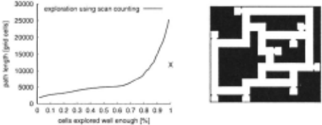
Figure 6 shows the result of a series of 50 simulation ex periments. In these experiments we forced the robot to reach a scan count of n where n varied between 1 and 130. 2 We counted the number of cells m that would be explored well enough given the entropy criterion for coverage maps and plotted the length of the overall path against m. The resulting graph is shown in Figure 6. The cross on the right side indicates the path length obtained when using the strategy CL for coverage maps. As can be seen, if more than 85% of the map should be explored well enough, a decision-theoretic explo ration strategy yields shorter trajectories than extended scan counting.
2 In practice, a good candidate value of n would be the maximum number of measurements necessary to obtain a coverage map that fulfills the entropy threshold criterion
5.2 A Comparison of the View-Point Selection Strategies
Robots performing 2-d exploration tasks with sonars oder laser scanners normally integrate every sensor measurement because the amount of data is reasonably small and easy to integrate. In this section we consider the situation that an alyzing a measurement produces high costs. This might by the case if e.g. the distance information needs to be extracted from stereo images. In such a situation the number of mea surements needed for the exploration task is a value of in terest. As mentioned above, one of the major advantages of our coverage maps is that they allow the integration of the uncertainty into the selection process of the next view-point. The experiments in this section are designed to compare the performance of the different strategies. To carry out the ex periments, we varied the size of the local window when using IG_WIN and the weight a: in the evaluation function ofiG_CL (see Equation (16)). In Figure 7 (a) and (b) the numbers be hind IG_CL show the value of the weight a: and the numbers behind IG_ WIN indicate the radius of a circle which defines the local window. The results have been obtained using 20 runs per strategy in the environment shown in Figure 7 (d). Please note that further experiments carried out in alternative environments showed similar results and are omitted for the sake of brevity. The maximum allowed entropy during all experiments described in this section was set to .6.
Figure 7 (a) shows the average number of measurements necessary to complete the exploration task for each strategy. As can be seen from the figure, the strategy IG needs the min imum amount of measurements. The strategy IG_CL with a: = 1.0 needs approximately the same number of measure-
..
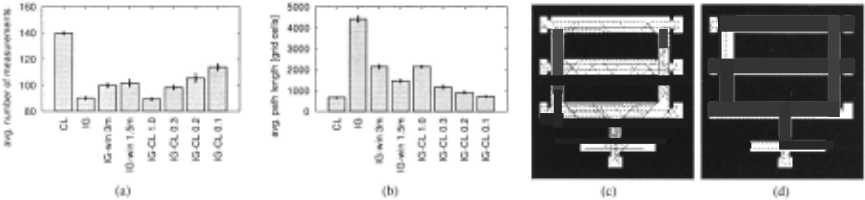
ments as IG. The strategy CL requires the maximum number of measurements compared to all other strategies considered here. The reason is that it only seeks to minimize the path length without considering the information gained at particu lar locations. The error-bars correspond to the 5% confidence interval.
In our experiments we found that a nearest neighbor view point selection strategy like CL outperforms an approach con sidering information gain if the robot is allowed to integrate measurements while it is moving (assuming that the acquisi tion and integration of measurements can be done fast). This can be seen in Figure 7 (b), which plots the average path length driven by the robot during the exploration task for all different strategies. With respect to the path length the strategy CL shows the best behavior as the resulting trajec tories are shorter than those of all other techniques. Thus, the CL strategy efficiently covers the terrain. In contrast to that, the IG strategy ignores the distance to be driven and therefore produces an extremely long path which results in the worst behavior of all strategies (see also Figure 7 (c) & (d)). The IG_CL strategy with a = .3 appears to yield a good trade-off between number of measurements and overall path length. According to the experiments it slightly outperforms the IG_WIN strategy.
6 Conclusions
In this paper we have introduced a new representation scheme for maps build with mobile robots from sensor data. In con trast to standard occupancy maps our coverage maps store a posterior for each cell about its coverage. This offers the opportunity to more accurately compute the uncertainty of the robot about the corresponding area in the environment. Additionally, we have presented a sensor model designed to update these maps upon sensory input. Finally, we have com pared decision-theoretic approaches to guide a vehicle during exploration.
The technique has been implemented and evaluated in ex tensive simulation runs and real world applications. The ex periments illustrate that by using coverage maps it is possible to build accurate maps even if noisy sensors are used. Exper iments analyzing different exploration strategies indicate that a technique combining the maximum uncertainty reduction and the distance to be traveled yields the best trade-off be tween the number of necessary measurements and the length of the resulting paths.
@inproceedings{ijcai2003p161,
  title     = {Exploring Unknown Environments with Mobile Robots using Coverage Maps},
  author    = {Stachniss, Cyrill and Burgard, Wolfram},
  booktitle = {Proceedings of the Eighteenth International Joint Conference on
               Artificial Intelligence, {IJCAI-03}},
  publisher = {International Joint Conferences on Artificial Intelligence},
  editor    = {Georg Gottlob and Toby Walsh},
  pages     = {1127--1133},
  year      = {2003},
  url       = {https://ijcai.org/proceedings/2003/161},
}
TY - CPAPER TI - Exploring Unknown Environments with Mobile Robots using Coverage Maps AU - Stachniss, Cyrill AU - Burgard, Wolfram T2 - Proceedings of the Eighteenth International Joint Conference on Artificial Intelligence, IJCAI-03 PB - International Joint Conferences on Artificial Intelligence PY - 2003 SP - 1127 EP - 1133 UR - https://ijcai.org/proceedings/2003/161 ER -Copied
Machine-readable versions of this paper, for tools and AI agents: