
iFire AI: AI-powered Wildfire Simulation and 3D Immersive Visualisation
Proceedings of the Thirty-Fifth International Joint Conference on Artificial Intelligence. AI and Social Good. Pages 7229-7238.
https://doi.org/10.24963/ijcai.2026/804
Keywords
- Humans and AI: Humans and AI
- Multidisciplinary Topics and Applications: Multidisciplinary Topics and Applications
- Machine Learning: Machine Learning
Abstract
Wildfires, especially extreme wildfires, can cause prolonged damage to natural environments, human lives and global economies. To mitigate these impacts, enhancing wildfire preparedness is critical. This research proposal introduces iFire AI, a collaborative project to develop a world-leading 3D immersive visualisation system that enables users to experience and understand extreme wildfire scenarios. iFire AI utilises our advanced 360-degree immersive system AVIE, which visualises interactive landscapes and wildfire events enhanced by AI techniques. Firstly, we propose a deep learning model for wildfire behaviour modelling that generates minute-resolution wildfire progression information for immersive visualisation, supported by a Sim2Real pipeline that integrates simulated and real-world data to address data insufficiency and enhance model development and evaluation. We also explore 3D tree reconstruction using 3D Gaussian splatting, creating visually realistic and computationally efficient tree models. iFire AI can enhance users' risk perception, situational awareness and collaborative decision-making, and thereby reduce risks due to extreme wildfires and promote sustainable development.
- [Borchers Arriagada et al., 2020] Nicolas Borchers Arriagada, An- drew J Palmer, David MJS Bowman, Geoffrey G Morgan, Bin B Jalaludin, and Fay H Johnston. Unprecedented smoke-related health burden associated with the 2019-20 bushfires in eastern australia. Medical Journal of Australia, pages 282-283, 2020.
- [Brits et al., 2024] Baylee Brits, Yang Song, and Carlos Tirado Cortes. Immersive visualisation systems as align- ment strategies for extreme event scenarios. In Climate Disaster Preparedness: Reimagining Extreme Events through Art and Technology, pages 65-76. Springer, 2024.
- [Brown, 2009] Tim Brown. Change by design: How design think- ing creates new alternatives for business and society. Harper- Collins Australia, 2009.
- [Byari et al., 2022] Mohamed Byari, A Bernoussi, Omar Jellouli, Mustapha Ouardouz, and Mina Amharref. Multi-scale 3d cellular automata modeling: Application to wildland fire spread. Chaos, Solitons & Fractals, page 112653, 2022.
- [Castrillón et al., 2011] M Castrillón, Pedro A Jorge, Ignacio J López, Adrián Macías, David Martín, Rafael J Nebot, Izzat Sab- bagh, Francisco M Quintana, Javier Sánchez, Antonio J Sánchez, et al. Forecasting and visualization of wildfires in a 3d geograph- ical information system. Computers & geosciences, pages 390- 396, 2011.
- [Coen et al., 2013] Janice L Coen, Marques Cameron, John Micha- lakes, Edward G Patton, Philip J Riggan, and Kara M Yedi- nak. Wrf-fire: coupled weather-wildland fire modeling with the weather research and forecasting model. Journal of Applied Me- teorology and Climatology, pages 16-38, 2013.
- [Cortes et al., 2023] Carlos A Tirado Cortes, Susanne Thurow, Alex Ong, Jason J Sharples, Tomasz Bednarz, Grant Stevens, and Dennis Del Favero. Analysis of wildfire visualization systems for research and training: are they up for the challenge of the current state of wildfires? IEEE transactions on visualization and com- puter graphics, pages 4285-4303, 2023.
- [Crawl et al., 2017] Daniel Crawl, Jessica Block, Kai Lin, and Ilkay Altintas. Firemap: A dynamic data-driven predictive wild- fire modeling and visualization environment. Procedia Computer Science, pages 2230-2239, 2017.
- [Del Favero et al., 2005] Dennis Del Favero, Neil Brown, Jeffrey Shaw, and Peter Weibel. T Visionarium: the aesthetic transcrip- tion of televisual databases, pages 132-141. Springer, 2005.
- [Del Favero et al., 2023] Dennis Del Favero, Yang Song, Khalid Moinuddin, Charles Green, Jason Sharples, Alex Ong, and Navin Brohier. Penumbra2.0. In SIGGRAPH Asia 2023 Art Gallery. Association for Computing Machinery, 2023.
- [Del Favero et al., 2024] Dennis Del Favero, Susanne Thurow, Maurice Pagnucco, and Ursula Frohne. Reimagining extreme event scenarios: The aesthetic visualisation of climate uncer- tainty to enhance preparedness. In Climate Disaster Prepared- ness: Reimagining Extreme Events through Art and Technology, pages 7-24. Springer, 2024.
- [Dosovitskiy et al., 2021] Alexey Dosovitskiy, Lucas Beyer, Alexander Kolesnikov, Dirk Weissenborn, Xiaohua Zhai, Thomas Unterthiner, et al. An image is worth 16x16 words: Transformers for image recognition at scale. In International Conference on Learning Representations, pages 1-21, 2021.
- [Drummond et al., 2020] Greg Drummond, Daryoush Habibi, and Marcus Cattani. A Handbook of Wildfire Engineering. Bushfire & Natural Hazard Cooperative Research Centre, Victoria, 2020.
- [Earth Resources Observation and Science Center, 2022] Earth Resources Observation and Science Center. Landsat level-3 burned area, collection 2. https://doi.org/10.5066/P999KPGS, 2022. Accessed: 2026-06-10. DOI
- [Eidenshink et al., 2007] Jeff Eidenshink, Brian Schwind, Ken. Brewer, et al. A project for monitoring trends in burn severity. Fire Ecology, 3:3-21, 2007.
- [Endsley, 2011] Mica R. Endsley. Designing for Situation Aware- ness: An Approach to User-Centered Design, Second Edition. CRC Press, Inc., 2011.
- [Finney, 1998] Mark A Finney. FARSITE, Fire Area Simulator- model development and evaluation. US Department of Agricul- ture, Forest Service, Rocky Mountain Research Station, 1998.
- [Finney, 2006] Mark A Finney. An overview of flammap fire mod- eling capabilities. In Fuels Management-How to Measure Suc- cess: Conference Proceedings, pages 213-220, 2006.
- [Flores Gonzalez et al., 2025] Mario Flores Gonzalez, Carlos A Tirado Cortes, and Dennis Del Favero. Tablet as an enabler for immersive visceral experiences. In Proceedings of the Extended Abstracts of the CHI Conference on Human Factors in Comput- ing Systems, CHI EA '25, 2025.
- [Guédon and Lepetit, 2024] Antoine Guédon and Vincent Lepetit. Sugar: Surface-aligned gaussian splatting for efficient 3d mesh reconstruction and high-quality mesh rendering. In Proceedings of the IEEE/CVF Conference on Computer Vision and Pattern Recognition, pages 5354-5363, 2024.
- [He et al., 2016] Kaiming He, Xiangyu Zhang, Shaoqing Ren, and Jian Sun. Deep residual learning for image recognition. In Pro- ceedings of the IEEE conference on computer vision and pattern recognition, pages 770-778, 2016.
- [Hoang et al., 2010] Roger V Hoang, Matthew R Sgambati, Timo- thy J Brown, Daniel S Coming, and Frederick C Harris Jr. Vfire: Immersive wildfire simulation and visualization. Computers & Graphics, pages 655-664, 2010.
- [Huang et al., 2025] Renhao Huang, Ali Asadipour, Dennis Del Favero, and Yang Song. iFire AI: AI-powered wildfire simulation and 3d immersive visualisation. In X-Fire 2025 - 1st International Workshop on Extreme Wildfire Events: Book of Abstracts, pages 22-26. COST Action NERO (CA22164) - European Network on Extreme Fire Behavior, 2025.
- [Jiang et al., 2023] Wenyu Jiang, Yuming Qiao, Guofeng Su, Xin Li, Qingxiang Meng, Hongying Wu, Wei Quan, Jing Wang, and Fei Wang. WFNet: A Hierarchical Convolutional Neural Net- work for Wildfire Spread Prediction. Environmental Modelling & Software, page 105841, 2023.
- [Joshi et al., 2025] Rakesh C. Joshi, Miguel G. Cruz, and Ran- dall J. Donohue. Nationally consistent mapping of wildland fuel types across australia using satellite-derived vegetation structural data. International Journal of Wildland Fire, 34(5):WF24224, 05 2025.
- [Kerbl et al., 2023] Bernhard Kerbl, Georgios Kopanas, Thomas Leimkühler, and George Drettakis. 3d gaussian splatting for real- time radiance field rendering. ACM Transactions on Graphics, pages 1-, 2023.
- [Li et al., 2024] Yanzhi Li, Keqiu Li, Li Guohui, Chanqing Ji, Lubo Wang, Die Zuo, et al. Sim2real-fire: A multi-modal simulation dataset for forecast and backtracking of real-world forest fire. In The Conference on Neural Information Processing Systems Datasets and Benchmarks Track, pages 1-15, 2024.
- [Lino et al., 2021] Hugo Lino, Rui Nóbrega, Fernando Birra, and Nuno Correia. Managing a crisis in virtual reality-tackling a wildfire. In Proceedings of the ACM Symposium on Virtual Real- ity Software and Technology, pages 1-3, 2021.
- [McGinity et al., 2007] Matthew McGinity, Jeffrey Shaw, Volker Kuchelmeister, Ardrian Hardjono, and Dennis Del Favero. Avie: a versatile multi-user stereo 360° interactive vr theatre. In Pro- ceedings of the Workshop on Emerging Displays Technologies: Images and beyond: The Future of Displays and Interacton, page 2-5, 2007.
- [Miller et al., 2015] Claire Miller, James Hilton, Andrew Sullivan, and Mahesh Prakash. Spark-a bushfire spread prediction tool. In Environmental Software Systems. Infrastructures, Services and Applications, pages 262-271, 2015.
- [Moinuddin et al., 2024] Khalid Moinuddin, Carlos Tirado Cortes, Ahmad Hassan, Gilbert Accary, and Frank Wu. Simulation of extreme fire event scenarios using fully physical models and vi- sualisation systems. In Climate Disaster Preparedness: Reimag- ining Extreme Events through Art and Technology, pages 49-63. Springer, 2024.
- [Penney and Richardson, 2019] Greg Penney and Steven Richard- son. Modelling of the radiant heat flux and rate of spread of wildfire within the urban environment. Fire, pages 1-24, 2019.
- [Penney et al., 2019] Greg Penney, Daryoush Habibi, and Marcus Cattani. Firefighter tenability and its influence on wildfire sup- pression. Fire Safety Journal, pages 38-51, 2019.
- [Radke et al., 2019] David Radke, Anna Hessler, and Dan Ellsworth. Firecast: Leveraging deep learning to predict wildfire spread. In Proceedings of International Joint Conference on Artificial Intelligence, pages 4575-4581, 2019. IJCAI
- [Ravi et al., 2024] Nikhila Ravi, Valentin Gabeur, Yuan-Ting Hu, Ronghang Hu, Chaitanya Ryali, Tengyu Ma, et al. Sam 2: Segment anything in images and videos. arXiv preprint arXiv:2408.00714, pages 1-, 2024.
- [Rhodes and Diaz, 2025] David Rhodes and Ruben Diaz. GSOPs: Gaussian Splatting Operators for SideFX Houdini. https://github. com/cgnomads/GSOPs, 2025. Accessed: 2026-06-10. Link
- [Ryan and Opperman, 2013] Kevin C. Ryan and Tonja S. Opper- man. Landfire -a national vegetation/fuels data base for use in fuels treatment, restoration, and suppression planning. Forest Ecology and Management, page 208-216, 2013.
- [Schönberger and Frahm, 2016] Johannes Lutz Schönberger and Jan-Michael Frahm. Structure-from-motion revisited. In IEEE Conference on Computer Vision and Pattern Recognition, pages 4104-4113, 2016.
- [Shadrin et al., 2024] Dmitrii Shadrin, Svetlana Illarionova, Fedor Gubanov, Ksenia Evteeva, Maksim Mironenko, Ivan Levchunets, et al. Wildfire spreading prediction using multimodal data and deep neural network approach. Scientific Reports, page 2606, 2024.
- [Sharples and Hilton, 2020] Jason J Sharples and James E Hilton. Modeling vorticity-driven wildfire behavior using near-field tech- niques. Frontiers in Mechanical Engineering, pages 1-69, 2020.
- [Sharples et al., 2016] Jason J Sharples, Geoffrey J Cary, Paul Fox- Hughes, Scott Mooney, Jason P Evans, Michael-Shawn Fletcher, Mike Fromm, Pauline F Grierson, Rick McRae, and Patrick Baker. Natural hazards in australia: extreme bushfire. Climatic Change, pages 85-99, 2016.
- [Song et al., 2024] Yang Song, Maurice Pagnucco, Frank Wu, Ali Asadipour, and Michael J Ostwald. Intelligent architectures for extreme event visualisation. In Climate Disaster Preparedness: Reimagining Extreme Events through Art and Technology, pages 37-48. Springer, 2024.
- [Sullivan et al., 2022] Andrew Sullivan, Elaine Baker, Tiina Kurvits, Alexandra Popescu, Alison K Paulson, Amy Cardi- nal Christianson, et al. Spreading like wildfire: The rising threat of extraordinary landscape fires. Technical report, United Nations Environment Programme, 2022.
- [Tedim et al., 2018] Fantina Tedim, Vittorio Leone, Malik Am- raoui, Christophe Bouillon, Michael R Coughlan, Giuseppe M Delogu, et al. Defining extreme wildfire events: Difficulties, challenges, and impacts. Fire, pages 1-9, 2018.
- [Tirado Cortes et al., 2024] Carlos Tirado Cortes, Dennis Del Favero, Greg Drummond, Richard Hurley, Yang Song, Frank Wu, and Michael Ostwald. iFire: AI Immersive Visualisa- tion to Enhance Fire Training Sensemaking, 2024.
- U.S. Geo- logical Survey and U.S. Forest Service. Geospatial multi- agency coordination (geomac) wildland fire support. https:// www.geomac.gov, 2018. Accessed: 2026-06-10. Link
- [USDA Forest Service, 2020] USDA Forest Service. National usfs fire occurrence point (feature layer). https://apps.fs.usda.gov/ arcx/rest/services/EDW/EDW FireOccurrenceAndPerimeter 01/ MapServer/9, 2020. Accessed: 2026-06-10. Link
- [van Eeden and Dickman, 2023] Lily M van Eeden and Christo- pher R Dickman. Estimating the number of wild animals affected by australia's 2019-20 wildfires. Australia's Megafires: Biodi- versity Impacts and Lessons from 2019-2020, page 154, 2023.
- [Wei et al., 2020] Xi Wei, Tianzhu Zhang, Yan Li, Yongdong Zhang, and Feng Wu. Multi-modality cross attention network for image and sentence matching. In IEEE/CVF Conference on Computer Vision and Pattern Recognition, pages 10938-10947, 2020.
- [Xiong and Huang, 2010] Qing Xiong and Xin-yuan Huang. Speed tree-based forest simulation system. In International Conference on Electrical and Control Engineering, pages 3033-3036, 2010.
- [Zhang et al., 2024] Baowen Zhang, Chuan Fang, Rakesh Shrestha, Yixun Liang, Xiaoxiao Long, and Ping Tan. Rade-gs: Rasterizing depth in gaussian splatting. arXiv preprint arXiv:2406.01467, pages 1-12, 2024.
References were extracted automatically from the PDF and may contain errors.
Full text extracted automatically from the PDF; figures, tables and equations may differ. The PDF is the version of record.
1 Introduction
Wildfires are unplanned, unpredictable and erratic fires affecting vast open areas and urban interfaces [Tedim et al., 2018]. As one of the most dangerous natural disasters, wildfires, especially extreme, cause irreversible damage to both natural and urban environments and impact life and property [Drummond et al., 2020]. In early 2020, Australia experienced its largest bushfire, which burnt 19 million hectares, impacted over three billion wild animals [van Eeden and Dickman, 2023], killed at least 34 people and affected 450 people from smoke inhalation [Borchers Arriagada et al., 2020], and caused up to 100 billion US dollars in economic losses. In early 2025, the Los Angeles wildfire killed 29 people and economic losses were estimated to reach $250 billion.
To mitigate such losses, it is essential to understand wildfire behaviours by offering education and training sessions for residents and firefighters, enhancing their risk perception, situational awareness and collaborative decision-making against wildfires [Drummond et al., 2020]. With the development of computer technologies, researchers and developers have been exploring more realistic wildfire simulations and more immersive wildfire visualisations [Cortes et al., 2023], enabling users to safely experience wildfire scenarios under different conditions without exposing users to dangerous wildfire zones.
1.1 iFire: 3D Immersive Visualisation forWildfire
UNSW's iCinema Research Centre launched the iFire project in 2021, aiming to develop the first fully immersive wildfire visualisation system [Del Favero et al., 2024; Brits et al., 2024; Tirado Cortes et al., 2024]. It translates the 2Dwildfire spread into a 3D space using Unreal Engine 5 (UE5) and then visualises them on our design-registered 360-degree 3D immersive visualisation system AVIE [McGinity et al., 2007].
Compared to existing 2D [Crawl et al., 2017; Miller et al., 2015; Finney, 2006] and 3D [Byari et al., 2022; Castrill´on et al., 2011] visualisations, our immersive visualisation system allows a more intuitive overview of wildfire by allowing full immersion of users inside a fire event with a better sense of how extreme fires interact with different landscapes and environmental conditions [Cortes et al., 2023]. Also, unlike other immersive visualisation platforms [Hoang et al., 2010; Lino et al., 2021] such as virtual reality [Lino et al., 2021], iFire allows users to physically collaborate with each other in wildfire scenarios. Therefore, iFire is suitable for applications such as wildfire training and education [Brits et al., 2024], and has thus attracted strong engagement from stakeholders such as FRNSW.
1.2 Project Proposal: iFire AI
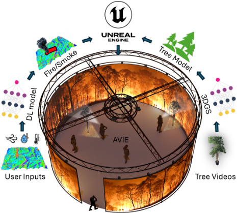
With the rapid progress of artificial intelligence (AI), particularly deep learning (DL), data-driven approaches have demonstrated significant success across numerous fields due to their ability to automatically learn complex patterns from real-world data. Motivated by these advances, we launched iFire AI in 2025 as an extension of iFire, aiming to feasibly integrate recent advanced AI technologies for extreme fire visualisation [Song et al., 2024]. As shown in Figure 1, we mainly focus on DL-based wildfire behaviour modelling and 3D Gaussian Splatting (3DGS) based tree modelling.
DL-based Wildfire Behaviour Modelling. In our previous version, iFire, wildfire scenarios were dynamically generated using physics-based models such as SPARK [Miller et al., 2015] and WRF-SFIRE [Coen et al., 2013]. However, these models rely solely on handcrafted physical rules or empirical formulations [Penney and Richardson, 2019] and are therefore often limited in scalability when applied to complex landscapes and varying weather conditions [Moinuddin et al., 2024]. As a result, DL-based wildfire behaviour modelling has emerged as a promising direction for enhancing model performance. By learning from real-world wildfire scenarios, such models have strong potential to capture complex dynamics beyond those explicitly encoded by human-designed rules.
In this project, we aim to design a deep learning (DL) model tailored for immersive visualisation. While deep learning has been explored in prior wildfire studies [Li et al., 2024; Radke et al., 2019; Shadrin et al., 2024], existing approaches primarily focus on wildfire forecasting by predicting fire perimeters or spread masks at coarse temporal intervals (e.g., daily or hourly scales), which are not well suited for immersive visualisation. In contrast, our model is designed to generate complete wildfire spread scenarios, conditioned on landscape, weather, and ignition inputs. Rather than predicting discrete fire perimeters at fixed time intervals, the model produces a fire-arrival-time map, where each pixel represents the estimated arrival time of fire in minutes, enabling minute-level temporal representation and meter-level spatial resolution for immersive visualisation. To effectively leverage deep learning while addressing the scarcity of real-world wildfire data, we introduce a Sim2Real pipeline in which the model is trained on simulated data and subsequently evaluated and adapted using real-world observations. We describe the data collection processes for both simulated and realworld datasets, along with a model adaptation strategy based on pseudo-labelling derived from final burnt areas. Unlike conventional wildfire forecasting studies that primarily focus on prediction accuracy, the novelty of this work lies in the formulation of wildfire behaviour modelling for immersive visualisation, the proposed Sim2Real development pipeline, the integration of simulation and real-world wildfire datasets, and the deployment of AI-generated wildfire scenarios within a collaborative immersive environment.
3DGS-based Tree Modelling. In wildfire scenarios, trees are core elements, and realistic tree modelling is therefore essential for enhancing immersive visualisation. However, in our current visualisation system, trees are manually reconstructed, making high-quality 3D mesh generation timeconsuming. This component explores 3DGS [Kerbl et al., 2023] for 3D tree reconstruction in wildfire environments, enabling the creation of visually realistic, computationally efficient, and dynamically interactive tree models. The proposed pipeline begins with the collection and preprocessing of tree video data and concludes with the generation of 3D tree meshes using advanced 3DGS-based methods [Gu´edon and Lepetit, 2024; Zhang et al., 2024]. This approach aims to bridge the gap between high-fidelity vegetation modelling and real-time environmental interaction, thereby advancing the capabilities of immersive wildfire training applications.
1.3 Major Contribution
The major contributions of iFire AI are fourfold. First, we formulate wildfire behaviour modelling for immersive visualisation through a minute-resolution wildfire progression representation. Unlike existing DL-based models [Li et al., 2024; Radke et al., 2019] that primarily predict fire perimeters at coarse temporal intervals, our formulation enables continuous reconstruction of wildfire dynamics suitable for interactive rendering and immersive training environments. Second, we propose a Sim2Real development pipeline that combines simulated and real-world wildfire data for model training, adaptation, and evaluation. This framework addresses the limited availability of high-resolution wildfire observations while supporting the development of data-driven wildfire behaviour models. Third, we investigate 3D Gaussian Splatting (3DGS) for vegetation reconstruction in wildfire environments, enabling the generation of visually realistic, computationally efficient, and dynamically interactive tree models for large-scale immersive visualisation. Finally, we integrate AI-generated wildfire scenarios and reconstructed vegetation models into the AVIE immersive visualisation platform, providing a collaborative environment for wildfire training, education, and research.
1.4 Collaborations
iFire AI is a multidisciplinary project that brings together expertise in fire science and artificial intelligence across UNSW, Fire and Rescue New South Wales (FRNSW), and international partners. iCinema at UNSW leads the project, driving the development of AI models and immersive simulation technologies for 3D visualisation, while the School of Computer Science and Engineering at UNSW co-develops the AI models and provides technical expertise in deep learning and computer graphics. FRNSW contributes operational knowledge in urban interface firefighting, supports emergency training applications, and assists with data acquisition. Bushfire Research at UNSW and CSIRO/Data61 provide fire science expertise, supporting and refining simulation models such as SPARK through insights into fire dynamics, weather influences, and real-world case studies [Sharples and Hilton, 2020; Sharples et al., 2016]. In addition, iFire AI collaborates with European partners, including the Royal College of Art for creative industry applications and the European Network on Extreme Fire Behaviour for emergency services use.
2 3D Immersive Visualisation System
360-degree Immersive Visualisation System. We develop a system capable of taking users on a virtual and visual experience of wildfires. This involves the use of our 3D cinema AVIE, a 360-degree 3D immersive and interactive cinema. As shown in Figure 1, this system exhibits wildfire scenarios on a 360-degree screen with a 4K resolution. Users wear 3D glasses to enable a tangible experience of the fire ground. AVIE supports multiple users to directly interact with each other, with no occlusions of the views. It is a promising visualisation system that has previously successfully deployed for multiple projects [Del Favero et al., 2023; Del Favero et al., 2005]. Therefore, AVIE can be an ideal visualisation system to maximally visualise wildfires.
3D Reconstruction. We use UE5, the most advanced 3D computer graphics game engine, to reconstruct the 2D wildfire scenarios at the urban interface in a 3D space. We follow the provided landscape maps and weather data to build the terrain and wind models. Fire rendering is built upon the existing particle system using wildfire progression reconstructed from the predicted fire-arrival-time and crownfire activity maps. Extra particles are created to simulate smoke and embers, with hard-coding to simulate their behaviours. For tree modelling, we currently test two approaches to improve realism and help maintain robust realtime performance. In pine trees, we use SpeedTree [Xiong and Huang, 2010], a leading software for digital vegetation development, to procedurally generate full tree structures. In grassland trees, we combine photogrammetry, which generates high-resolution 3D trunk models from photos, with SpeedTree to refine and extend scanned tree trunks with procedural 3D branching structures.
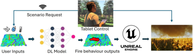
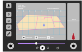
Interactive Control. A tablet in our system allows users to control the visualisation system remotely by touching the tablet screen [Flores Gonzalez et al., 2025]. As illustrated in Figure 2, the tablet shows simplified landscapes and fire spread, as well as values of essential parameters such as wind and temperature conditions. In addition, we design two main interactive functions: perspective switch, which allows users to switch between aerial view and ground to crown view and hence providing situational awareness from multiple angles essential for understanding the complex variables affecting fire behaviour, and progress control, which controls the progress of the fire spread, which can reduce visual clutter in the immersive environment.
3 DL-basedWildfire Behaviour Modelling
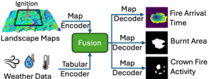
For wildfire behaviour modelling, our model architecture can be designed as in Figure 3. First, the model takes three categories of input variables. Landscape information is represented as multi-channel maps that include topography, vegetation, and fuel characteristics [Ryan and Opperman, 2013]. Weather conditions are provided as tabular data capturing temperature, wind speed and direction, and humidity. Finally, the ignition is a two-dimensional coordinate indicating the point of fire initiation. To integrate these three inputs, we first crop the landscape maps so that the ignition is centred, so that all fires originate from the centre of the image. Then, the maps can be encoded using image encoders, such as ResNet [He et al., 2016] or Vision Transformer [Dosovitskiy et al., 2021]. The weather information can be encoded using a transformer-based tabular encoder [Li et al., 2024]. Both weather and landscape features can be fused via crossattention [Wei et al., 2020].
Then, our model is designed to produce two primary outputs and one auxiliary output. The first primary output is a fire-arrival-time map, represented as a two-dimensional field in which each pixel denotes the estimated arrival time of fire in minutes as in [Jiang et al., 2023; Finney, 1998]. Combined with the predicted burnt-area mask, wildfire progression can be reconstructed from the fire-arrival-time map. The second primary output captures crown-fire activity, expressed as a two-dimensional map that identifies the spatial locations where crown fire occurs. In addition, the model predicts a burnt-area mask indicating the final burnt extent of the wildfire, which is used both for wildfire progression reconstruction and as an auxiliary task to support model training. To support these outputs, a multi-head decoder is designed, where the fused features are fed into separate output decoders for each task. Specifically, one decoder predicts the fire-arrival-time map, a second decoder predicts the burntarea mask, and a third decoder predicts the binary or probabilistic crown-fire activity map. Each head is optimised using a task-specific loss function, allowing the model to learn complementary but distinct aspects of wildfire behaviour.
The model can be extended to predict auxiliary fire information, if the data allowed, by adding extra headers. For example, flame height can be represented as a two-dimensional map, where each pixel denotes the estimated flame height (e.g., in meters) at the time the fire reaches that location, which can be obtained via an image-based decoder.
3.1 Sim2Real Model Development Pipeline
Since our model is intended to generate wildfire scenarios from ignitions, extensive training and evaluation data describing wildfire progression are required. However, obtaining such data from real-world sources is currently impractical for three main reasons. First, most available wildfire imagery is derived from two categories of satellite data. For example, Landsat and Sentinel-2 provide relatively high spatial resolution of 30 meters but have revisit intervals exceeding ten days, whereas MODIS and VIIRS offer daily observations at the cost of much coarser spatial resolution of 1 km. Second, the ignition points are extremely difficult to obtain, which are either unreported or recorded with significant spatial and temporal uncertainty. Finally, other relevant data, such as flame height, are largely unavailable.
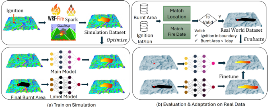
To mitigate this problem, inspired by [Li et al., 2024], we plan to follow a Sim2Real pipeline to develop our model as shown in Figure 4, which trains the model on simulated data while adapting and evaluating it using collected real-world data. The proposed Sim2Real framework aims to bridge physically grounded wildfire simulators and data-driven wildfire behaviour modelling for immersive visualisation.
Train on Simulation. Training from simulated data can be a promising way to build our DL model to learn basic physical rules. To achieve this, we first construct a training dataset by randomly simulating wildfire scenarios using mathematical models [Finney, 1998; Coen et al., 2013; Miller et al., 2015]. For the United States, we sample approximately 10,000 regions, each covering 15.36 × 15.36km2 , and obtain landscape data from LANDFIRE [Ryan and Opperman, 2013], resulting in 512 × 512 maps at 30 m spatial resolution. All other inputs, including weather conditions, are randomly sampled from existing weather databases. Finally, fire arrival time maps are produced using FARSITE over a 24-hour simulation period. For Australia, wildfire scenarios are generated using the Spark Simulator [Miller et al., 2015] with data from NBIC [Joshi et al., 2025]. Preliminary implementations of the wildfire behaviour modelling framework have been reported in [Huang et al., 2025], providing initial evidence for the feasibility of learning wildfire progression from simulation-generated datasets.
Evaluation on Real-world Data. As shown in Figure 4b, Collecting comprehensive real-world wildfire data with both high temporal and spatial resolutions is impossible at the current stage. To simplify the data collection process, we evaluate simulated burnt areas against real-world observations at available time frames. Specifically, we first collect ignition locations from existing fire occurrence databases, including fire Occurrence data from MTBS [Eidenshink et al., 2007] and USFS [USDA Forest Service, 2020] database. For each ignition, we retrieve all available fire perimeters observed between 8 and 26 hours after ignition from multiple sources, including GeoMac [U.S. Geological Survey and U.S. Forest Service, 2018], MTBS Fire Perimeter [Eidenshink et al., 2007], Sim2Real-Fire [Li et al., 2024], and the Landsat burnt Area Science Products [Earth Resources Observation and Science Center, 2022]. We further filter out samples with invalid ignitions, such as those located outside burnt areas or cases where no valid fire boundaries can be obtained. In addition, as wildfire progression is often disrupted by firefighting activities, we prioritise cases with larger burnt areas and longer burning durations. Finally, model outputs are resampled to the required spatial and temporal resolutions, and the available frames are selected for comparison with the corresponding ground truth. To improve diversity and reduce potential sampling bias, we collect wildfire events across multiple regions, vegetation types, fire sizes, and environmental conditions. A statistical analysis of key attributes, including fire size, duration, and biome type, will be conducted after dataset construction to assess dataset diversity and coverage.
Model Adaptation. To take full advantage of DL techniques, the model needs to be adapted using the collected real-world data through model fine-tuning and more advanced semi-supervised learning techniques. Our strategy proceeds as follows. First, we use our simulation dataset to train a new model ("Label Model" in Figure 4a) that incorporates a binary map of the final burnt area as an additional input to generate fire progression outputs. Leveraging this extra information, the model is able to produce more accurate and realistic fire spread dynamics. Next, we select realworld samples with burnt area ground truth available within 24 hours after ignition and use the new model to reconstruct the full fire progression. The newly generated burnt areas at intermediate time steps are then treated as pseudo-labels and used to facilitate semi-supervised learning.
3.2 Integration for Visualisation
To let users control the parameters, we first add a variable control function on our tablet, which allows users to reset weather conditions, switch landscapes and select ignition locations. These parameters are used to prepare the inputs and sent to our wildfire simulation model to generate the corresponding wildfire scenarios. UE5 loads these data to reconstruct the 3D scenario. For the fire spread, it follows Section 2 to read the fire-arrival-time map to render burning and burnt regions over time. Then, the crown-fire activity maps are used to control the flames on trees. Flame height information, if available, can be used to control the shapes of flames. By utilising the data provided by our DL-based simulation model rather than handcrafted modelling in iFire, we believe the 3D reconstruction in iFire AI will be more realistic.
4 3DGS-based Tree Modelling
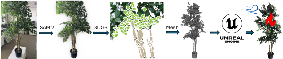
Trees play a crucial role in shaping landscapes, influencing fire dynamics, and defining visual and physical characteristics of forest environments. To accurately simulate these complexities in extreme wildfire scenarios, it is essential to develop realistic 3D tree models that capture not only structural and visual fidelity but also dynamic interactions with fire and the surrounding landscape. However, tree reconstruction presents significant challenges due to its complex geometry, occlusions, variable lighting conditions, and diverse environmental contexts. Unlike stationary, well-lit objects, trees exhibit fine-scale branching, dense foliage, and intricate selfshadowing, making their virtual reconstruction both computationally intensive and technically demanding. To solve this problem, we propose to model trees using 3DGS, a new 3D reconstruction algorithm that employs machine learning techniques. The overall pipeline is shown in Figure 5.
Video Data Collection. The pipeline begins with video acquisition for trees before and after burning. To record these two states on the same tree, we plan to take the videos the day before and after the hazard reduction burning events held by FRNSW. In addition, the accuracy of the 3D reconstruction heavily relies on the quality of the input data. We use a camera rig with known internal parameters or a smartphone camera to capture a 360° side-view video of the tree. To optimise the data collection process, it is essential to maintain a uniform focal length and constant exposure time throughout the recording. Additionally, capturing the tree from various angles, particularly focusing on thin and detailed parts, will improve the overall quality of the reconstruction.
Data Preprocessing. Once the video data is collected, the next step involves isolating the tree by eliminating irrelevant background elements and improving processing efficiency. This step ensures that the 3D reconstruction process focuses exclusively on the tree's structure, reducing noise and leading to a cleaner and more precise point cloud for further processing. We choose the Segment Anything Model 2 (SAM 2) [Ravi et al., 2024] to perform video segmentation, which utilises interactive prompts across multiple frames to segment the foreground tree structures effectively, with a streaming memory mechanism to ensure the consistency of the segmentations across frames. Then we extract 100-300 key frames from the segmented video. These frames serve as input for reconstruction, where the COLMAP library [Sch¨onberger and Frahm, 2016] is utilised to initialise the point cloud. This process involves estimating the external camera parameters (tilt and position) by matching pixels between images, which is accomplished in a matter of seconds.
3D Gaussian Splatting Processing. After preprocessing, we perform 3DGS to reconstruct the trees. By refining the parameters of each Gaussian, including position, covariance, colour, and alpha transparency, 3DGS ensures that the rendered images closely match the original photographs taken from the camera positions. A differentiable renderer is used to facilitate this optimisation, allowing for precise adjustments based on the input data.
We directly use state-of-the-art 3DGS models such as SuGaR [Gu´edon and Lepetit, 2024] and RaDe-GS [Zhang et al., 2024]. SuGaR improved 3DGS by encouraging better alignment with object surfaces and binding the coarse representation to a higher-resolution mesh, allowing for further refinement of surface geometry and fine details. RaDe-GS introduces a rasterised method to compute the depth and surface normal maps, improving structural coherence and depth accuracy by leveraging 3D geometry priors. Therefore, these two methods provide efficient approaches to tree reconstruction, generating high-resolution 3D tree models as point clouds or UV-mapped meshes.
3D Reconstruction. Our reconstructed trees will be optimised to be integrated into UE5 using Houdini [Rhodes and Diaz, 2025], which enables both radiance field manipulation and the generation of a low-poly proxy mesh for efficient animation. To animate the trees, the proxy mesh is rigged (given an internal skeleton that can then be manipulated to create motion) using SideFX Labs tools, and the extracted skeleton is encoded into Pivot Painter 2.0 data, allowing branch and foliage movement in UE5. This approach eliminates the need for computationally expensive physics simulations, allowing for believable, dynamic motion while maintaining real-time performance. We retain the current method of using fire propagation masks and material blending techniques to simulate tree burn progression over time using the texture transition from a healthy tree to a burnt tree.
5 Evaluation Criteria
Deep Learning Models. When evaluating our deep learning models, it is important to consider the level of realism. Model outputs should closely match the corresponding reference labels, which can be evaluated via qualitative results through visualisation and quantitative results through mathematical evaluation metrics for both tasks.
For wildfire behaviour modelling, we use the intersectionof-union (IoU) to compare the predicted regions against the corresponding reference labels. To be more specific, the fire spread is measured at two levels. For temporal dynamics, we convert the predicted fire-arrival-time map into fire spread masks at selected time steps and compute temporal IoU against the corresponding ground truth. To evaluate the burnt area, we compute IoU on the final burnt area to assess the spatial consistency of the complete wildfire progression [Huang et al., 2025]. This two-level evaluation strategy allows both temporal wildfire progression and overall fire extent to be assessed separately. Finally, crown-fire activity maps are evaluated using IoU as a binary spatial prediction.
For 3D tree modelling, Structural Similarity Index Measure, Peak Signal-to-Noise Ratio, and Learned Perceptual Image Patch Similarity are used to assess reconstruction quality by comparing rendered images from different viewpoints against reference observations [Kerbl et al., 2023].
Immersive Visualisation. For the wildfire visualisation system, the level of realism is the most important evaluation. The following aspects will be used: User-Centered Design (UCD) [Endsley, 2011] and Design Thinking (DT) [Brown, 2009] methodologies to ensure that firefighter feedback directly informs the system's development. UCD emphasises iterative prototyping and user feedback, allowing us to assess realism through structured evaluations at different design stages. Meanwhile, DT provides a framework for understanding user needs by encouraging physically dynamic research and rapid iteration. To gather meaningful insights, firefighter will be interviewed using a semi-structured protocol, combining open-ended questions using specific prompts focused on key realism factors such as environmental fidelity, fire behaviour, and sensory immersion. This allows participants to freely express their experiences and perceptions. Additionally, contextual inquiry will be incorporated, where firefighters interact with the system while describing their thought processes, and comparative questioning, asking them to compare the simulation to real-world experiences. By integrating these approaches, the level of realism can be systematically refined based on expert feedback, ensuring the visualisation system remains both immersive and effective for training. Although expert evaluation remains the primary assessment strategy, it will be complemented by structured user studies and quantitative rating scales measuring perceived realism, situational awareness, usability, and training effectiveness.
| Phase | DLModel | Tree Modelling | Immersive Visualisation |
|---|---|---|---|
| 2025 | Simulation data collection, model development. | Video acquisition& preprocessing. | Initial integration into the AVIE platform. |
| I | Real-world data collection and ini- tial deployment. | Preprocessing, and model develop- ment. | Development and system refine- ment. |
| II | Sim2Real adaptation using real- world data. | Tree model embedding and optimi- sation in UE5. | System integration and user- centred evaluation. |
| III | Final Model deployment, bench- marking and validation. | Final Asset deployment & material evaluation. | Deployment & stakeholder evalua- tion. |
6 Development Plans
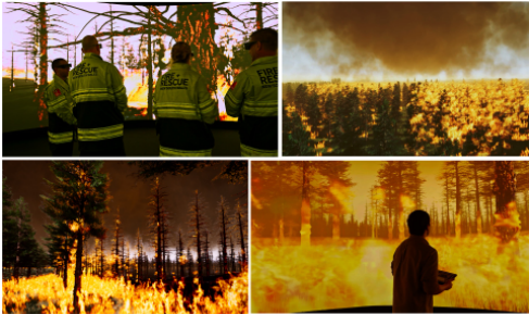
Currently, we have demonstrated our iFire using a hypothetical pine plantation fire generated using the Spark simulator, a grasslands fire in the Australian state of Victoria in 2022 and the Bridger Foothills Fire in Montana, USA in 2021. Positive comments and feedback have been received by our stakeholders. Then, the current visualisation system has been deployed by FRNSW for emergency services training shown in Figure 6 and the Australian Broadcasting Corporation (ABC) for its online news divisions. Moreover, our AVIE 360-degree platform is industrially scalable, with mobile variants (130° and 100°) that have been deployed across over 50 international venues. More details are in our iFire project page.
For the AI component, preliminary progress has already been achieved. We have constructed simulation datasets using FARSITE and Spark and developed initial prototype models for wildfire behaviour prediction. Preliminary quantitative results have been reported in [Huang et al., 2025], demonstrating the feasibility of learning wildfire progression from simulated wildfire scenarios. Ongoing work focuses on expanding the real-world dataset and developing the proposed Sim2Real adaptation framework. Our future plan will follow the implementation plan in Table 1, mainly focusing on developing AI models, collecting required data and validating the proposed framework.
7 Social Impacts
A report from the UN environment programme [Sullivan et al., 2022] illustrates that wildfires can cause potentially longlasting damage to wildlife, humans and vegetation, impacting around eight United Nations' Sustainable Development Goals (UN SDGs). iFire AI aims to contribute to these goals by providing a wildfire simulation and visualisation system for better preparedness, response and recovery for wildfires, especially extreme wildfires, and thereby reduce risks. We conclude that iFire AI has the following applications.
Firefighter Training. Themain purpose of iFire AI is to allow experienced firefighters and incident commanders to engage in simulated emergency situations under extreme wildfire events that impact urban areas. Our system allows firefighters to see how different weather conditions can impact extreme fire behaviour from diverse physical locations. This also enables new firefighters to navigate and interact within virtual scenarios, improving their situational awareness and decision-making skills [Cortes et al., 2023].
Table 1: Implementation roadmap of iFire AI (each phase: 4 months).
Education. Beyond firefighter training, iFire AI also serves as an educational tool for at-risk residents and volunteers, enhancing awareness during extreme wildfires in urban areas. Through immersive visualisation, the system demonstrates fire spread, smoke behaviour, and evacuation routes, helping users develop situational awareness and decision-making skills. Interactive scenarios teach critical survival strategies, including recognising high-risk conditions, understanding wind-driven fire behaviour, and identifying safe and tenable zones [Cortes et al., 2023; Penney et al., 2019]. Guided training modules tailored to different user groups further ensure accessibility for non-experts.
Research. In this project, we first leverage AI technologies for wildfire simulation. This will enable future wildfire researchers to better learn and explore fire behaviours through our simulation platform. In addition, iFire AI is a typical multidisciplined project that can inspire research collaborations among computer science, fire modelling, arts and climate science for other wildfire projects.
8 Conclusion
This research proposal introduces iFire AI, aiming to develop a world-leading AI-powered wildfire simulation and immersive visualisation system. The immersive visualisation is built upon the world-leading 360-degree visualisation platform AVIE, enabling multiple users to collaboratively interact while experiencing realistic wildfire scenarios. For the AI component, we propose deep learning-based wildfire behaviour models supported by a Sim2Real development pipeline that integrates both simulated and real-world data to enhance model robustness and accuracy. The proposed models are designed to generate physically meaningful and temporally consistent wildfire progression information, including fire spread dynamics and crown-fire activity, for immersive visualisation and interactive scenario generation. To further improve visual realism, we incorporate 3D Gaussian Splatting (3DGS) for high-fidelity tree modelling. Finally, iFire AI demonstrates how AI, environmental modelling, and immersive visualisation can be integrated into a unified platform for preparedness, training, and risk communication.
Disclaimer: Views expressed in the paper are those of the authors and do not necessarily represent those of any affiliated organisations.
A About the Authors
Renhao Huang
iCinema Research Centre, UNSW, AU
Dr. Renhao Huang is a Postdoctoral Research Fellow at UNSW's iCinema Research Centre. He has completed his PhD study in 2025 at the School of Computer Science and Engineering, UNSW, focusing on computer vision in human behaviour modelling and human trajectory prediction. His current work focuses on applying machine learning techniques to wildfire simulation and other AIpowered wildfire reconstruction.
Lara Clemente
iCinema Research Centre, UNSW, AU
Lara Clemente is a 3D artist and researcher pursuing a practicebased Master of Fine Arts at the iCinema Research Centre, UNSW. With a background in architecture, landscape, and sustainability in IUAV University of Venice, her research focuses on flora modelling under extreme fire conditions in virtual environments to enhance the understanding of fire ecology and climate-driven landscapes.
Mario Flores Gonzalez
iCinema Research Centre, UNSW, AU
Mario Flores Gonz´alez is a PhD student at the iCinema Centre, UNSW, specialising in interaction design, with a diverse background spanning motion graphics, filmmaking, and design. Currently, his research focuses on implementing interactive frameworks within immersive virtual spaces for fire training applications. This work aims to revolutionise fire training methodologies by integrating cuttingedge technology into immersive learning environments.
Yang Song
School of Computer Science and Engineering, UNSW, AU
Associate Professor Yang Song is an ARC Future Fellow at School of Computer Science and Engineering, UNSW. Her research interests include computer vision, biomedical image analysis and machine/deep learning. She has published over 200 peer-reviewed papers in top-tier international conferences and journals. Song has led iFire's integration of machine learning approaches.
Greg Drummond
Fire and Rescue New South Wales, AU
Dr Greg Drummond (Penney) is an Assistant Commissioner with Fire and Rescue New South Wales, and Adjunct Professor with the University of New South Wales. His research interests are applied critical systems thinking metacognition, emergency management, and wildfire engineering.
Gonzalo Herrera
Fire and Rescue New South Wales, AU
Gonzalo Herrera is an Inspector with Fire and Rescue New South Wales (FRNSW), and has a background in 2D/3D design and application. With his design skills and 19 years operational experience with the FRNSW, Gonzalo is currently introducing new immersive learning platforms that fire fighters can utilise to enhance safety within their roles and responsibilities.
Jason Sharples
Bushfire Research, UNSW, AU
Professor Jason Sharples is an internationally recognised authority in dynamic bushfire behaviour and extreme bushfire development, whose pioneering research has extensively influenced both policy and practice in Australia and internationally. As an expert advisor and witness to the NSW Independent Bushfire Inquiry following the 2019-20 Black Summer fires, the resulting recommendations are framed by Sharples' research. He has extensive experience in practice-led bushfire research, close engagement with government and the emergency services industry, and broad community outreach.
Michael J. Ostwald
iCinema Research Centre, UNSW, AU
Professor Michael J. Ostwald is the Co-Director of iCinema Research Centre. He was previously an EU Distinguished Professor, Dean of the Built Environment at the University of Newcastle, professorial fellow at Victoria University Wellington and Adjunct Professor at Royal Melbourne Institute of Technology. He completed postdoctoral research on applications of spatial computing in architecture at University of California LA, Canadian Centre for Architecture (McGill, Montreal) and Harvard (Mass.). He is the author of 17 books and over 140 journal articles. Michael is Editor-inChief of the Nexus Network Journal: Architecture and Mathematics (Springer) and sits on the editorial boards of Architectural Research Quarterly (Cambridge) and Architectural Theory Review (Taylor &Francis).
Maurice Pagnucco
School of Computer Science and Engineering, UNSW, AU
Professor Maurice Pagnucco is an internationally renowned expert in AI and particularly, knowledge representation and reasoning. He is the Deputy Dean (Education) of the Faculty of Engineering at UNSW. He was previously the Head of the School of Computer Science and Engineering (CSE) from July 2010 to September 2019. He is a Professorial Fellow at the iCinema Centre for Interactive Cinema Research, Deputy Director of Creative Robotics Lab (CRL) and CoDirector of the Intelligent Environments Lab. He is also currently Vice President of the Computing Research and Education Association of Australasia (CORE).
Ali Asadipour
Computer Science Research Centre, Royal College of Art, UK Associate Professor Ali Asadipour leads the UK's Royal College of Arts (RCA)'s Computer Science Research Centre, specialising in immersive experiences and AI. His international influence is amplified by holding Senior Visiting Fellowship positions at the University of New South Wales and Korea Advanced Institute of Science & Technology, facilitating collaborations with esteemed global research labs and assuming pivotal roles in national knowledge exchange networks. Before joining RCA, he spearheaded interdisciplinary research groups at Warwick University, overseeing a multitude of internationally funded projects. With a PhD, MSc and BSc (Hons) in computer science and engineering, he possesses over a decade of academic and industrial acumen and has co-founded and held the role of Chief Technology Officer in technology-focused enterprises.
Dennis Del Favero
iCinema Research Centre, UNSW, AU
Professor Dennis Del Favero is a research artist and ARC Laureate Fellow, Scientia Professor of Digital Innovation, Director of the iCinema Research Centre at the University of New South Wales and Visiting Professor Royal College of Art (UK). He is a former Executive Director of the Australian Research Council - Humanities and Creative Arts. His work has been widely exhibited in major group exhibitions including Film Cologne, Battle of the Nations War Memorial Leipzig, SIGGRAPH, ISEA and in solo exhibitions in museums such as ZKM Karlsruhe. His work is represented by Galerie Brigitte Schenk, Cologne and Mais Wright Gallery, Sydney. At present he is leading the development of an AI based extreme fire 3D visualisation system for use by fire science, emergency response, TV and Online broadcasters and museums.
Acknowledgements
This research was supported by the Australian Government through the Australian Research Council's Laureate funding scheme (FL200100004).
@inproceedings{ijcai2026p804,
  title     = {iFire AI: AI-powered Wildfire Simulation and 3D Immersive Visualisation},
  author    = {Huang, Renhao and Clemente, Lara and Flores Gonzalez, Mario and Song, Yang and Drummond, Greg and Herrera, Gonzalo and Sharples, Jason and Ostwald, Michael and Pagnucco, Maurice and Asadipour, Ali and Del Favero, Dennis},
  booktitle = {Proceedings of the Thirty-Fifth International Joint Conference on
               Artificial Intelligence, {IJCAI-26}},
  publisher = {International Joint Conferences on Artificial Intelligence Organization},
  editor    = {Diego Calvanese},
  pages     = {7229--7238},
  year      = {2026},
  month     = {8},
  note      = {AI and Social Good},
  doi       = {10.24963/ijcai.2026/804},
  url       = {https://doi.org/10.24963/ijcai.2026/804},
}
TY - CPAPER TI - iFire AI: AI-powered Wildfire Simulation and 3D Immersive Visualisation AU - Huang, Renhao AU - Clemente, Lara AU - Flores Gonzalez, Mario AU - Song, Yang AU - Drummond, Greg AU - Herrera, Gonzalo AU - Sharples, Jason AU - Ostwald, Michael AU - Pagnucco, Maurice AU - Asadipour, Ali AU - Del Favero, Dennis T2 - Proceedings of the Thirty-Fifth International Joint Conference on Artificial Intelligence, IJCAI-26 PB - International Joint Conferences on Artificial Intelligence Organization PY - 2026 SP - 7229 EP - 7238 DO - 10.24963/ijcai.2026/804 UR - https://doi.org/10.24963/ijcai.2026/804 ER -Copied
Machine-readable versions of this paper, for tools and AI agents:





