
A Robust Noise Resistant Algorithm for POI Identification from Flickr Data
Proceedings of the Twenty-Sixth International Joint Conference on Artificial Intelligence. Main track. Pages 3294-3300.
https://doi.org/10.24963/ijcai.2017/460
Keywords
- Machine Learning: Unsupervised Learning
- Multidisciplinary Topics and Applications: AI and Social Sciences
- Machine Learning: Data Mining
- Machine Learning: Machine Learning
Abstract
Point of Interests (POI) identification using social media data (e.g. Flickr, Microblog) is one of the most popular research topics in recent years. However, there exist large amounts of noises (POI irrelevant data) in such crowd-contributed collections. Traditional solutions to this problem is to set a global density threshold and remove the data point as noise if its density is lower than the threshold. However, the density values vary significantly among POIs. As the result, some POIs with relatively lower density could not be identified. To solve the problem, we propose a technique based on the local drastic changes of the data density. First we define the local maxima of the density function as the Urban POIs, and the gradient ascent algorithm is exploited to assign data points into different clusters. To remove noises, we incorporate the Laplacian Zero-Crossing points along the gradient ascent process as the boundaries of the POI. Points located outside the POI region are regarded as noises. Then the technique is extended into the geographical and textual joint space so that it can make use of the heterogeneous features of social media. The experimental results show the significance of the proposed approach in removing noises.
- [Bui et al., 2015] Thanh-Hieu Bui, Yong-Jin Han, Seong- Bae Park, and Se-Young Park. Detection of poi bound- aries through geographical topics. In ICBigComps, pages 162-169. IEEE, 2015.
- [Canny, 1986] John Canny. A computational approach to edge detection. PAMI, 8(6):679-698, 1986.
- [Charikar, 2002] Moses S Charikar. Similarity estimation techniques from rounding algorithms. In STOC, pages 380-388. ACM, 2002.
- [Cheng et al., 2013] Chen Cheng, Haiqin Yang, Michael R. Lyu, and Irwin King. Where you like to go next: Succes- sive point-of-interest recommendation. In IJCAI, 2013. IJCAI
- [Cheng, 1995] Yizong Cheng. Mean shift, mode seeking, and clustering. PAMI, 17(8):790-799, 1995.
- [Comaniciu and Meer, 2002] Dorin Comaniciu and Peter Meer. Mean shift: A robust approach toward feature space analysis. PAMI, 24(5):603-619, 2002.
- [Crandall et al., 2009] David J. Crandall, Lars Backstrom, Daniel P. Huttenlocher, and Jon M. Kleinberg. Mapping the world's photos. In WWW, pages 761-770, 2009.
- [Ester et al., 1996] Martin Ester, Hans-Peter Kriegel, Jörg Sander, and Xiaowei Xu. A density-based algorithm for discovering clusters in large spatial databases with noise. In KDD, pages 226-231, 1996.
- [Hinneburg and Keim, 1998] Alexander Hinneburg and Daniel A. Keim. An efficient approach to clustering in large multimedia databases with noise. In KDD, pages 58-65, 1998.
- [Kennedy and Naaman, 2008] Lyndon S. Kennedy and Mor Naaman. Generating diverse and representative image search results for landmarks. In WWW, pages 297-306, 2008.
- [Kurashima et al., 2010] Takeshi Kurashima, Tomoharu I- wata, Go Irie, and Ko Fujimura. Travel route recommenda- tion using geotags in photo sharing sites. In CIKM, pages 579-588, 2010.
- [Liu et al., 2013a] Bin Liu, Yanjie Fu, Zijun Yao, and Hui Xiong. Learning geographical preferences for point-of- interest recommendation. In KDD, pages 1043-1051, 2013.
- [Liu et al., 2013b] Xin Liu, Yong Liu, Karl Aberer, and Chunyan Miao. Personalized point-of-interest recommen- dation by mining users' preference transition. In CIKM, pages 733-738, 2013.
- [Manku et al., 2007] Gurmeet Singh Manku, Arvind Jain, and Anish Das Sarma. Detecting near-duplicates for web crawling. In WWW, pages 141-150. ACM, 2007.
- [Manning et al., 2008] Christopher D Manning, Prabhakar Raghavan, and Hinrich Schütze. Introduction to informa- tion retrieval, volume 1. Cambridge university press Cam- bridge, 2008.
- [Popescu and Shabou, 2013] Adrian Popescu and Aymen Shabou. Towards precise POI localization with social me- dia. In MM, pages 573-576, 2013.
- [Purwar and Singh, 2016] Archana Purwar and Sandeep Ku- mar Singh. DBSCANI: noise-resistant method for missing value imputation. J. Intelligent Systems, 25(3):431-440, 2016.
- [Rae et al., 2012] Adam Rae, Vanessa Murdock, Adrian Popescu, and Hugues Bouchard. Mining the web for points of interest. In SIGIR, pages 711-720, 2012.
- [Vu and Shin, 2015] Dung D Vu and Won-Yong Shin. Low- complexity detection of poi boundaries using geo-tagged tweets: A geographic proximity based approach. In SIGSPATIAL Workshop, page 5. ACM, 2015.
- [Yang et al., 2011] Yiyang Yang, Zhiguo Gong, and Leong Hou U. Identifying points of interest by self-tuning clustering. In SIGIR, pages 883-892, 2011.
- [Yang et al., 2014] Yiyang Yang, Zhiguo Gong, and Leong Hou U. Identifying points of interest using heterogeneous features. ACM TIST, 2014.
- [Yilmaz, 2007] Alper Yilmaz. Object tracking by asymmet- ric kernel mean shift with automatic scale and orientation selection. In CVPR, pages 1-6. IEEE, 2007.
- [Ying et al., 2013] Josh Jia-Ching Ying, Wang-Chien Lee, and Vincent S. Tseng. Mining geographic-temporal- semantic patterns in trajectories for location prediction. ACM TIST, 5(1):2, 2013.
- [Ying et al., 2014] Josh Jia-Ching Ying, Eric Hsueh-Chan Lu, Wen-Ning Kuo, and Vincent S Tseng. Mining user check-in behavior with a random walk for urban point-of- interest recommendations. ACM TIST, 2014.
- [Yuan et al., 2013] Quan Yuan, Gao Cong, Zongyang Ma, Aixin Sun, and Nadia Magnenat-Thalmann. Time-aware point-of-interest recommendation. In SIGIR, pages 363- 372, 2013.
- [Zhang et al., 2012] Haipeng Zhang, Mohammed Korayem, Erkang You, and David J. Crandall. Beyond co- occurrence: discovering and visualizing tag relationship- s from geo-spatial and temporal similarities. In WSDM, pages 33-42, 2012.
- [Zhao et al., 2009] Qi Zhao, Zhi Yang, Hai Tao, and Wen- tai Liu. Evolving mean shift with adaptive bandwidth: A fast and noise robust approach. In ACCV, pages 258-268, 2009.
- [Zheng and Xie, 2011] Yu Zheng and Xing Xie. Learning travel recommendations from user-generated gps traces. ACM TIST, 2(1):2, 2011.
- [Zheng et al., 2009] Yu Zheng, Lizhu Zhang, Xing Xie, and Wei-Ying Ma. Mining interesting locations and travel se- quences from gps trajectories. In WWW, pages 791-800, 2009.
- [Zheng et al., 2012] Yan-Tao Zheng, Zheng-Jun Zha, and Tat-Seng Chua. Mining travel patterns from geotagged photos. ACM TIST, 3(3):56, 2012.
References were extracted automatically from the PDF and may contain errors.
Full text extracted automatically from the PDF; figures, tables and equations may differ. The PDF is the version of record.
1 Introduction
Flickr contains more than 8 billions photos from 8.7 million users; in addition, 3.5 million new photos are uploaded to Flickr daily where a substantial number of these photos come
∗We thank the anonymous reviewers for their many insightful comments and suggestions. This work was supported in part by: NSFC-Guangdong JF (U1501254), NSFC (61603101, 61472089, 61472337), NSF-Guangdong (2014A030306004, 2014A030308008), STPP of Guangdong (2015B010108006, 2015B010131015), FDCT of Macau Government (FDCT/116/2013/A3, FDCT/007/2016/AFJ), UMAC RC (MYRG201500070-FST, MYRG2017-00212-FST, MYRG2016-00182-FST), GuangdongHPSSP(2015TQ01X140), TPP of Guangzhou (201610010101, 201604016075)
†Corresponding Author: fstzgg@umac.mo
from the mobile devices 1 . Such massive amounts of photos with heterogeneous meta-data (geographical and textual tags) are valuable resources to support various mining tasks and have resulted in many research problems, such as Point of Interest (POI) identification [Yang et al., 2014], the POIbased applications [Crandall et al., 2009], photo tag analysis [Zhang et al., 2012] and travel pattern recognition [Zheng et al., 2012].
According to our survey, plenty of travel recommendation works [Cheng et al., 2013; Ying et al., 2013; Popescu and Shabou, 2013; Ying et al., 2014] require a predefined POI database as the input to their recommendation algorithms. It is no doubt that the quality of the POI database is critical to the success of their subsequent processes. In this paper, we propose a robust noise-resistant approach for POI identification using geo- and textual-tagged social media data.
In general, the POI database can be automatically constructed by performing some clustering algorithms over the geo-tagged datasets (i.e., Flickr photos). However, the crowdcontributed data like Flickr often contain large amounts of noises which may generate pernicious effects to the quality of the identified POI. A robust algorithm for POI identification is definitely desired from POI-based applications.
1.1 Motivations &Contributions
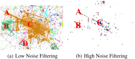
When visiting a city, people may take photos anywhere, and a large percent of which are POI irrelevant. In this paper, such POI-irrelevant geo-tagged photos are regarded as noises, because they can cause the identified POIs to be significantly deviated from the actual ones. To solve the issue, some techniques are proposed[Ester et al., 1996; Hinneburg and Keim, 1998; Zhao et al., 2009; Purwar and Singh, 2016] , where a density threshold is used to filter out the lower density points as noises. However, such a global setting cannot handle the noise problem well because of the various density values among POIs. Figure 1 shows the situations of the DBScan algorithm[Ester et al., 1996] with two extreme settings of the density threhold. Figure 1(a) is the result of a lower filtering threshold where two urban POIs, (A) Arc De Triomphe and (C) Louvre Museum in the downtown area are merged together. At the same time, a large amount of irrelevant data points (geo-tagged photos) are included in the result as well. In contrast, if we overly increase the threshold (Figure 1(b)), then it will partition one POI region into many small clusters and at the same time some important POIs (e.g. (D) Montparnasse Cemetery) may be omitted just because of their relatively lower density. In this paper, we aim at tackling the problem.
1 https://en.wikipedia.org/wiki/Flickr
To handle the noise issue, we propose a novel approach based on the Laplacian Zero-Crossing Technique [Canny, 1986]. It is constructed based on the relative change of the geographical density. This idea is motivated by an observation that the density of geo-tagged photos encounters a drastic change when crossing the POI boundaries. The Laplacian of the density function indicates the speedup of the gradient ascending and it changes from positive to negative when crossing the boundaries of the POI region (Zero-Crossing of the Laplacian). We attempt to capture such "changes" automatically in the identification, thus thoroughly overcome the problem caused by the global density threshold setting.
Flickr photos are not only tagged with geographical locations, but also texts. The quality of the identified POI can be further improved if the textual features are taken into account. For such a sake, we apply Local Sensitive Hashing (LSH) algorithm [Charikar, 2002] to transform a term vector into a hashing value and exploit Hamming Distance [Manku et al., 2007] to measure the difference between two photos in the textual space. This technique can benefit our algorithm from two aspectives: (1) it significantly reduces the computational cost for the distance evaluation between textual tags (2) with defined distance metric, it enables to extend Laplacian ZeroCrossing algorithm into the Geographical × Textual joint space.
The contributions of this work are summarized as follows:
- We propose a novel technique, Laplacian ZeroCrossing Detecting, to remove noisy data (POI irrelevant), along the gradient ascent process. The technique is based on the drastic change of the local density increase, thus can thoroughly overcome the global setting problem of the density threshold.
- We extend the proposed techniques into the joint space crossing both geographical and textual features, which can further improve the quality of POI identification.
- Experiments on real datasets collected from Flickr demonstrate the effectiveness of our algorithm.
1.2 Organization of the Paper
The reminder of this paper is organized as follows. Section 2 and Section 3 respectively introduce the Hill-Climbing algorithm and Laplacian Technology. In Section 4, we describe how to integrate the textual feature into the framework. We thoroughly evaluate our proposed techniques on the photo collections of Flickr in Section 5. We discuss the related work in Section 6 and summarize our work in Section 7.
2 POI Identification Using Gradient Ascent Algorithm
Intuitively, a location is attractive if visitors take more photos around it. In other words, the location with the highest density of geo-tagged photos among its neighbors is probably a POI. Formally, given a set of geo-tagged photos x1, . . . , xN in the 2-dimensional Euclidean space R2 , the density function of a location x can be estimated through a Kernel K as follows [Cheng, 1995]:
where g is the geographical bandwidth parameter (e.g. 100 meters). In this paper, Gaussian Kernel G is exploited for its excellent features (i.e. simple and infinite differentiable, easy gradient estimation). By replacing K by G in Equation 1, the normalized gradient of Tg can be computed as:
Instead of ▽Tg(x), we use ▽lnTg(x) in this work, for its fast converging speed and easy estimation [Comaniciu and Meer, 2002].
In our scenario, the city POIs are located at places x with ▽lnTg(x) = 0. To look for all POIs in a city, we start the gradient ascent algorithm with any photo x0 , then iteratively conduct the following Hill-Climbing Algorithm:
where α is a parameter for controlling the size of the movement, xj is the j th state of the gradient ascent movement starting from x0 , and xj will converge to xm with Tg(xj ) monotonically increasing until ▽lnTg(xm) = 0. Hence, the xm is a stationary point and is called the location of a POI, while the sequence of successive states xj , j = 0, ...,m is called the trajectory of x.
According to the Capture Theorem, the trajectory is attracted by a local maximum if the xm is close enough to it, the trajectory will eventually converge to a local maximum which serves as the urban POI. Thereby, Hill-Climbing approach normally terminates if the shift distance is smaller than a predefined threshold δg or the number of iterations exceeds the corresponding constraint. Photos (or points) of converging to the same local maximum are assigned into the same POI.
As discussed in the Introduction Section, the POIs may include a large percent of noise photos, which significantly bias the identified results. To remove the noises, works [Ester et al., 1996][Hinneburg and Keim, 1998] set a threshold fg, such that all photos with Tg(x) < fg are discarded as noises. This technique is extensively employed in the Hill-Climbing approach[Cheng, 1995; Comaniciu and Meer, 2002; Crandall et al., 2009]. However, it is difficult to set a right value for fg as discussed in the Introduction Section. In next subsection, we propose a method for adaptively detecting noises based on the change of the local density.
3 Laplacian Technique for Noise Reduction
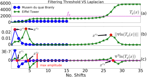
To understand the principles of our proposed technique intutively, in Figure 2 we plot the values of Tg(xj ), ||▽ln Tg(xj )|| via the shift movement iteration xj (x-axis ) for two trajectories which converge to POI Eiffel Tower and Mus´ee du quai Branly, respectively.
As shown in Figure 2 (a), the density of Eiffel Tower is much larger than that of Mus´ee du quai Branly. If a global density threshold is used to remove the noise photos as in [Ester et al., 1996; Hinneburg and Keim, 1998], it is probably that the less popular POI (Mus´ee du quai Branly) will be missed since its density (e.g. 500) is under the filtering threshold fg (e.g. 2000). Generally speaking, landmarks located in downtown areas often have a much larger density value than those ones located in the marginal areas. To solve the problem, we propose to adaptively filter the noises according to the intensive change of the density along the trajectories in the Hill-Climbing process.
In a Hill-Climbing process, the magnitude of ▽lnTg(xj ) indicates the increase rate of Tg(x) at the j-th step. Normally, Tg(xj ) is monotonically increasing until xj converges to the POI. It is intuitive that the gradient ascent movement will encounter a steepest ascent when passing the boundary of the POI. We define the Influence Region IR(xm) of a urban POI xm as an area within which the xm and its neighbor photos share similar densities. Thereby during the HillClimbing process Tg(xj ) changes steadily if it locates inside the IR(xm), while it changes drastically when it is shifting into the region. We attempt to capture such changes as the critical points to separate noise and non-noise photos.
According to our observation, two types of trajectories are distinguished: (1) The trajectory converges to a POI steadily. (2) The trajectory passes one or more drastic changes in terms of the density increase and finally reaches a POI.
In the former situation, the Hill-Climbing is a steady process because the photo and its whole trajectory is located inside the "region" of the POI. While in the latter case, the rapid intensive change of Tg(xj ) could be interpreted as the boundary of the POI. As shown in Figure 2, each intensive change (e.g. xc1 , xc2 and xc3 ) is probably a boundary towards POI and separates (classify) the significant and relatively less significant photos in terms of the geographical density. In other words, the boundary-crossing can be utilized to automatically distinguish the POI relevant photos from noisy ones.
Determining such kind of boundaries is a problem that aims to find the critical point xc which locates in the boundary between sparse area (i.e., steady change of Tg(xj )) and dense area (i.e., intensive change of Tg(xj )) in a trajectory. For the first type of trajectories, there is no critical point because of the steady climbing process, which means it is unnecessary to perform the noise filtering. Regarding the second type, only part of the trajectory is included in the influence region while the critical point services as the separation between POI relevant photos and noisy ones.
3.1 Zero-Crossing Detecting of Laplacian
To detect such critical point(s) in a trajectory, we propose to exploit the Laplacian Zero-Crossing of the logarithmnormalized density function lnTg(x). This idea is motivated by the edge detection problem in image processing [Canny, 1986]. Formally, the Laplacian operator of lnTg(x) is defined as:
Therefore, the Laplacian operator of ln Tg(x) can be easily computed by reusing the value of Tg(x) and ||▽lnTg(x)||. To apply the operator to the boundary detecting in the HillClimbing algorithm, we compare the sign of ▽2 lnTg(xj ) with that of ▽2 lnTg(xj+1 ). The gradient movement is said to cross the boundaries of a POI if we have:
In case that two or more points, say xj1 , xj2 , ..., xjK , satisfy the Laplacian Zero-Crossing along the Hill-Climbing trajectory, we define the boundary point as the one xjk which makes the value of ||▽2 lnTg(xjk ) -▽2 lnTg(xjk+1 )|| (amplitude) maximum.
In Figure 2 (b) and (c), we plot the value of ||▽lnTg(x)|| and that of ▽2 lnTg(x) via the Hill-Climbing shift, respectively. Point xc1 , xc2 , and xc3 are detected as the Laplacian zero-crossing points of ▽2 ln Tg(x), which corresponds to the local maximum points of ||▽ ln Tg(x)||, respectively.
Algorithm 1 Detection Influence Region By Laplacian
Input: POI set P with trajectories.
Output: POI set P ∗ with pruned trajectories
- 1: for each POI p in P do
- 2: for each trajectory t of p do
- 3: compute normalized Laplacian ▽2 lnTg(x)′ by Equation 4
- 4: compute the zero-crossing points of normalized Laplacian by Equation 5
- 5: if there exists one or more zero-crossing points then
- 6: find the zero-crossing point with maximum amplitude xcmax
- 7: prune the trajectory t from xcmax to the end as t∗ and add t∗ as trajectory of p
- 8: else
- 9: add t as trajectory of p without pruning
Algorithm 1 demonstrates how to find the Influence Region by the Laplacian. The normalized Laplacian is computed (line 3), according to which the zero-crossing points are detected. In Line 4 the critical point with maximum amplitude is retained as the boundary point since it indicates the most drastic change in density increment. An example is given in Figure 2 (c), the trajectory to Eiffel Tower has two critical points xc2 and xc3 , and the xc2 with maximum amplitude is selected to tune the trajectory (Line 6).
4 Extending the Techniques into the Joint Space
Besides the geographical feature, Flickr photos are tagged with rich texts too. Recently, works [Bui et al., 2015; Vu and Shin, 2015] attempt to identify POI boundaries using texts, in which the POI boundaries are determined by the drastic change of the text similarity between the detecting point and the POI center. However, both works require that the POI database, including the POI center (exact location) and its textual description (extracted fromWikipedia), should be available in advance. In this work, we extend the proposed Laplacian Zero-Crossing technique to the joint space of geographical and textual dimensions. This idea is motivated by the observation that the photos (or other geo-textual-tagged social media like Tweeter) are often described using similar texts within the same region of a POI. These two features together can further improve the quality of the identified POIs.
In the joint space of G×S (G: the geographical space; S: the textual space), let x = (x:g, x:s) denote the point in the space. Similar to works[Comaniciu and Meer, 2002; Yilmaz, 2007], we define the Multi-Variate Kernel in the joint space as:
where g and s are the bandwidth parameters in the two spaces respectively, xi = (xi:g, xi:s) and x = (x:g, x:s) are the joint vectors of the geographical and textual features.
A joint vector x = (x:g, x:s) is of length 2 + d, where the first two dimensions consist of the latitude and longitude of the geo-tagged photos and the last d dimensions represent the total number of terms in the vocabulary. The x:s records the TF · IDF 2 values of the tags in x. So, the textual feature of a photo is represented as a d-dimensional vector of terms. The distance of two text vectors xi:s - x:s is defined as the Hamming Distance. Before computing the Hamming Distance, it is necessary to convert the text vector into a Local Sensitive Hash (LSH) [Charikar, 2002; Manku et al., 2007] string: a binary hashing value of length l (l ≪ d). Hamming Distance between the hashing values gives the approximative textual difference between the respective vectors (photos). LSH technique is adopted for several reasons: (1) the cost to textual distance computation is reduced: only l bits comparison; (2) LSH considers the significance (weight) of the textual tag as well; and (3) the time of neighborhood search in textual space can be further reduced if the corresponding indexing technology is employed.
With the Multi-Variant Kernel (c.f. Equation 6), the density function in the joint space is defined as:
With the Equation 7, we correspondingly have the normalized gradient in the joint space as:
and ▽xs lnTg,s(x) is derived as:
The Laplacian of the joint density function can be easily computed as:
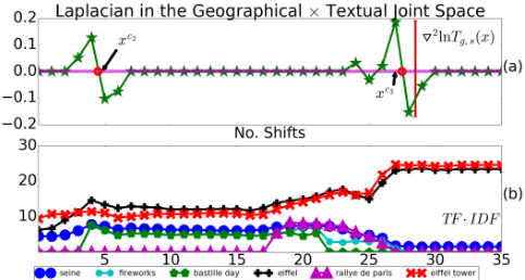
With the equations above, we can re-write the HillClimbing and Laplacian Zero-Crossing algorithms in the joint space. Geo-tagged photos are assigned into the same POI cluster if both of their geographical and textual features converge consistently. In Figure 3, we plot the density Laplacian of the Trajectory to Eiffel Tower in the Joint Space. Besides, in Figure 3 (b), the Top 6 TF ·IDF tags of Eiffel Tower are listed: if the feature from the textual space is taken into account, we will probably select xc3 as the critical point of the trajectory since it reflects the density change in the joint space. Further, as we will show in our experiments, the Laplacian Zero-Crossing technique is more robust resistant to the noises.
2TF and IDF follow the standard definitions as in information retrieval. TF denotes the frequency of a term in a document. IDF denotes the Inverse Document Frequency of the term.
| City | No. photos No. points | Latitude and Longitude | No. MBRs |
|---|---|---|---|
| Paris | 796,427 216,300 | [48.815 48.903 2.223 2.474 ] | 989 |
| New York | 1,067,964 274,428 | [ 40.499 40.931 -74.258 -73.713] | 492 |
| Rome | 343,917 96,738 | [41.790 41.989 12.368 12.624] | 254 |
5 Evaluation
In this section, we extensively evaluate our proposed techniques using three photo datasets collected from Flickr. We use the Flickr API 3 to collect the photos (including geographical locations, textual tags, and taken time) of a city. Specifically, we use the name of a city as the search query and keep only relevant photos (i.e., the geo-location is inside of the boundary of city) in our collection. The statistic of our dataset collections is listed in Table 1. We select three representative cities: New York, Paris and Rome. It should be noticed that the number of photos is much more than the number of points, because several photos might be taken at a single point.
In order to evaluate the identified Influence Region (IR), we use the POI information extracted from OpenStreetMap 4 as the ground truth: the POIs are retrieved if labeled with "tourism" 5 . For each POI in the ground truth, we use its MinimumBounding Rectangle (MBR) as the actual region. The number of MBRs is shown in fourth column of the Table 1.
The objective of evalution is to measure the similarity between identified Influence Region (IR) and the ground truth MBR. To achieve it, it is necessary to define metrics: (1) F1 score: P = TP TP+FP ,R = TP TP+FN , F1 = P∗R∗2 P+R where P and R denotes the precision and recall respectively. (2) Normalized Mutual Information (NMI): NMI(MBR, IR) =
3 http://www.flickr.com/services/api/
4 www.openstreetmap.org
5 visited on 2016/11/01
I(MBR;IR) [H(MBR)+H(IR)]/2 , where I is the mutual information and H is the entropy. Readers may refer to [Manning et al., 2008] for the detail of the metrics. For both metrics, a higher value indicates the better identification quality.
In this paper, several baseline approaches are evaluated in our experiments (G : geographical space, S : textual space):
- DBScan[Ester et al., 1996] is evaluated as well since it is widely used in geographic based mining tasks[Ester et al., 1996; Zheng et al., 2009; 2012; Ying et al., 2014; Purwar and Singh, 2016].
- HC refers to the Mean Shift approach[Cheng, 1995; Hinneburg and Keim, 1998; Crandall et al., 2009; Zhao et al., 2009]. HCg (Equation 2) and HCg,s (Equation 8) refer to the Mean Shift in the G space and the G×S joint space respectively.
- Laplacian refers to our proposed noise resistent framework. It is feature independent where Laplaciang and Laplaciang,s denote its applications to the G space and the G×S joint space respectively.
For all approaches, we select five different values for the geographical setting: 10, 30, 50, 80, 100 (g in meter). For the G×S joint space based approaches HCg,s and Laplaciang,s, since we adopt Local Sensitive Hash (LSH) to accelerate the textual distance computation, the length of Hash value (l) is set to 128, while the textual bandwidth (s in Hamming Distance) varies among 30, 50, 60, 80, 100. The global threshold (for min phts in DBScan and fg in HC) are set to 50 through our preliminary experiment.
In our implementation, R*tree is used as the index and costs O(logN) for each geographical range query where N is the number of points, thus the complexity of DBScan is O(NlogN). The complexity of Hill-Climbing is O(NMlogN) where M is the number of average steps (shifts) for a point to coverage. The complexity of our approach is O(NMlogN + NM), it incurs an additional cost of NM because of the zero-crossing detection in each trajectory.
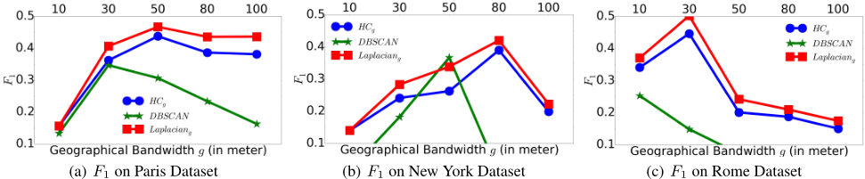
First, we evaluate the approaches in the geographical space. By varying the geographical parameter g, the performances of the approaches in terms of F1 on three Urban datasets are shown as in Figure 4. Laplaciang is better than HCg in all settings because it can automatically find the central area of the POI while the less significant points are labeled as noises. Compared to HCg, our Laplaciang gains 12% improvement on average in terms of F1 over the three data collections. In NMI comparison, Laplaciang outperforms HCg and DBScan in all settings. On average, 3% improvement can be achieved if Laplacian Technique is applied to HCg. The detail of NMI comparison is not listed because of the space limitation. The experiments on the geographical space demonstrate that the proposed Laplacian Technique is an effective approach against noises.
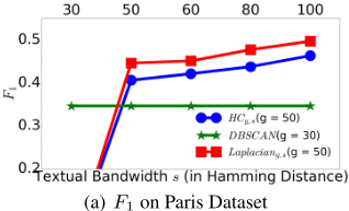
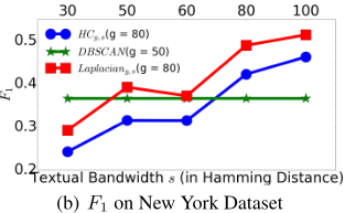
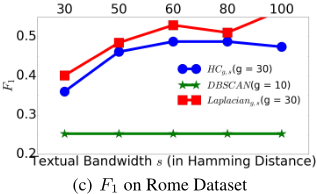
Second, for HCg and DBScan we fix the geographical parameter g to the setting which leads to the best F1: e.g. Paris g = 50 meters, New York g = 80 meters, Rome g = 30 meters, and further evaluate the performance by varying the value of s (textual bandwidth). In the G×S joint space, in terms of the metric F1 (Figure 5), our approach improves the identification quality in almost every setting. According to the range setting of textual bandwidth (s), a small value of s would lead to small POI regions. The corresponding improvement made by our algorithm is limited. However, if we set the textual bandwidth s large enough (larger than 50), the performance of our proposed approach is outstanding.
| g(meter) | Paris | New York | Rome | |||
|---|---|---|---|---|---|---|
| F1 | NMI | F1 | NMI | F1 | NMI | |
| 30 | 11.05% | 2.99% | 3.52% | 1.57% | 9.88% | 1.29% |
| 50 | 6.65% | 1.98% | 8.01% | 1.82% | 12.75% | 1.99% |
| 80 | 10.00% | 2.65% | 18.03% | 2.80% | 25.44% | 1.98% |
| 100 | 8.95% | 2.21% | 22.25% | 2.26% | 27.49% | 2.60% |
As a summary, Table 2 shows the Performance of Joint Laplaciang,s over HCg,s. For each setting of g, we compute the relative improvement over HCg,s by varing textual bandwidth s. It is obvious that our approach works much better if multi-features are used.
6 RelatedWorks
Based on location-aware photos, the works [Kennedy and Naaman, 2008] identify the POIs by information in the geographical space. Yang et al. [Yang et al., 2011; 2014] propose to integrate multiple information into the identification process. The authors in [Crandall et al., 2009; Kurashima et al., 2010] detect the landmarks (POI) by Mean Shift[Cheng, 1995]. Zheng et al. in [Zheng et al., 2009] use a density-based approach to find POI hierarchy. In [Zheng et al., 2012], the authors attempt to detect the user travel patterns by making use of geographical (DBScan [Ester et al.,
1996] based), temporal and textual features. The authors in [Bui et al., 2015][Vu and Shin, 2015] propose different algorithms to identify the POI boundaries while the POI location information is required as the input.
Zheng and Xie [Zheng and Xie, 2011] construct a framework to recommend personalized traveling sequences by collaborative filtering (CF)-based model. Ying et al. [Ying et al., 2014] design a system to recommend POIs in a "randomwalk" manner. Liu et al. [Liu et al., 2013a] solve the same problem by learning the geo-influence of the users' behaviors while [Liu et al., 2013b] focus on the POI category information. Coincidentally, the authors in [Cheng et al., 2013] and [Yuan et al., 2013] respectively study the successive and time-aware recommendation. Based on the Web Knowledge, Adam et al. [Rae et al., 2012] design a POI information recognization framework. Ying et al. [Ying et al., 2013] propose a framework to extract users' traveling patterns. The works mentioned above require a geo- and text-ware POI database which can be automatically constructed by our algorithm.
7 Conclusion
In this paper, we propose a novel noise resistent framework for discovering Urban POIs based on textual-tagged footprints. We provided a technique to identify the POI influence region by Laplacian. Besides we also demonstrated how to integrate the geographical and textual information of the photos into the discovering process. Finally, extensive experiments are conducted to verify our claims and discussions. We believe that our techniques are particularly useful in modern travel recommendation works.
@inproceedings{ijcai2017p460,
  title     = {A Robust Noise Resistant Algorithm for POI Identification from Flickr Data},
  author    = {Yang, Yiyang and Gong, Zhiguo and Li, Qing and U, Leong Hou and Cai, Ruichu and Hao, Zhifeng},
  booktitle = {Proceedings of the Twenty-Sixth International Joint Conference on
               Artificial Intelligence, {IJCAI-17}},
  publisher = {International Joint Conferences on Artificial Intelligence Organization},
  editor    = {Carles Sierra},
  pages     = {3294--3300},
  year      = {2017},
  month     = {8},
  note      = {Main track},
  doi       = {10.24963/ijcai.2017/460},
  url       = {https://doi.org/10.24963/ijcai.2017/460},
}
TY - CPAPER TI - A Robust Noise Resistant Algorithm for POI Identification from Flickr Data AU - Yang, Yiyang AU - Gong, Zhiguo AU - Li, Qing AU - U, Leong Hou AU - Cai, Ruichu AU - Hao, Zhifeng T2 - Proceedings of the Twenty-Sixth International Joint Conference on Artificial Intelligence, IJCAI-17 PB - International Joint Conferences on Artificial Intelligence Organization PY - 2017 SP - 3294 EP - 3300 DO - 10.24963/ijcai.2017/460 UR - https://doi.org/10.24963/ijcai.2017/460 ER -Copied
Machine-readable versions of this paper, for tools and AI agents:





